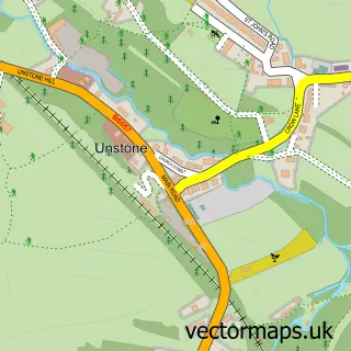
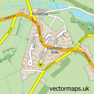
This Unstone Green street map is a detailed vector street map covering a 750m x 750m area. Select a larger area to create and download your own vector street map of Unstone Green.
The 750-metre map sample for Unstone Green covers 227 mapped buildings and approximately 12.3 km of road detail, of which 17 named roads are named. The immediate area includes 3 GP surgeries within 2 miles, 2 pubs and 15 MOT stations within 2 miles. The wider area around Unstone Green features 2 food and drink venues. To create a larger or custom map of Unstone Green, the map builder lets you define your own coverage area and download editable SVG, PDF and PNG files.
Create a larger editable map of Unstone Green
Choose any area you need and generate a high-quality vector map instantly. Perfect for print, planning, design, business and personal use.

This Unstone Green street map in Derbyshire is available as downloadable SVG, PDF and PNG map files, or as a printed map for planning, business, display, education, local information and design work. You can also create a larger custom map area using the map selector.
What this Unstone Green map sample shows
Unstone Green lies within Unstone Cp parish, part of Unstone ward in the North East Derbyshire District local authority area. The postcode geography for this area includes the S postcode area, the S18 postcode district and the S18 4 postcode sector. Residents fall under the Nhs Derby And Derbyshire Integrated Care Board for NHS services.
Local features near Unstone Green
Within 2 milesAmenities and services in and around Unstone Green.
Administrative and postcode information for Unstone Green
The local authority covering Unstone Green is North East Derbyshire District, within the county of Derbyshire. The settlement lies within Unstone ward and Unstone Cp civil parish. The S18 postcode district and S18 4 postcode sector serve the immediate area. NHS provision in the area is delivered through Chesterfield Royal Hospital Nhs Foundation Trust.
Nearby street map samples around Unstone Green

More street maps in Derbyshire
750 metre map area coverage
Boundary, postcode and point of interest information for the 750m x 750m rectangle centred on this sample map.
Boundaries containing map centre
Constituency: North East Derbyshire Co Const
County: Derbyshire County
District: North East Derbyshire District
Icb: NHS Derby and Derbyshire ICB
Parish: Unstone CP
Police Force: derbyshire
Postcode District: S18
Postcode Sector: S18 4
Ward: Unstone Ward
Nearby boundaries intersecting sample
Constituency: Chesterfield Boro Const
District: Chesterfield District (B)
Postcode District: S41
Postcode Sector: S41 9
Ward: Whittington Ward
Postcode coverage
POI category counts
Building Supply Store: 2
Pub: 2
Advertising Agency: 1
Beauty Salon: 1
Bridal Shop: 1
Builders: 1
Business: 1
Gardener: 1
Gas Station: 1
Industrial Equipment: 1
Sample points of interest
- Greystones Printing
- Lavender Aesthetics
- Karl's Photography Centre
- Autumn Building & Landscaping
- Hedge Above the Rest
- Plumbhaste
- R A Property Services
- Easy Grass UK
- Brown's Autocare
- Key Engineering
- PavLock
- Easy Grass Landscaping
Create a larger editable map of Unstone Green
This sample shows only a 750 metre area. To create a larger map of Unstone Green, use our map builder to choose your own coverage area, add titles and download editable SVG, PDF and PNG files.
Create a custom map of Unstone Green