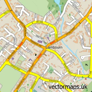
This Upper Lambourn street map is a detailed vector street map covering a 750m x 750m area. Select a larger area to create and download your own vector street map of Upper Lambourn.
The 750-metre map sample for Upper Lambourn covers 131 mapped buildings and approximately 8.6 km of road detail, of which 2 named roads are named. The immediate area includes 1 GP surgery within 2 miles and 2 MOT stations within 2 miles. The wider area around Upper Lambourn features 1 tourism point of interest. To create a larger or custom map of Upper Lambourn, the map builder lets you define your own coverage area and download editable SVG, PDF and PNG files.
Create a larger editable map of Upper Lambourn
Choose any area you need and generate a high-quality vector map instantly. Perfect for print, planning, design, business and personal use.

This Upper Lambourn street map in Berkshire is available as downloadable SVG, PDF and PNG map files, or as a printed map for planning, business, display, education, local information and design work. You can also create a larger custom map area using the map selector.
What this Upper Lambourn map sample shows
Upper Lambourn lies within Lambourn Cp parish, part of Lambourn ward in the West Berkshire local authority area. The postcode geography for this area includes the RG postcode area, the RG17 postcode district and the RG17 8 postcode sector. Residents fall under the Nhs Buckinghamshire, Oxfordshire And Berkshire West Integrated Care Board for NHS services.
Local features near Upper Lambourn
Within 2 milesAmenities and services in and around Upper Lambourn.
Administrative and postcode information for Upper Lambourn
Upper Lambourn lies within Lambourn Cp parish, part of Lambourn ward in the West Berkshire local authority area. The postcode geography for this area includes the RG postcode area, the RG17 postcode district and the RG17 8 postcode sector. Residents fall under the Nhs Buckinghamshire, Oxfordshire And Berkshire West Integrated Care Board for NHS services.
Nearby street map samples around Upper Lambourn

More street maps in Berkshire
750 metre map area coverage
Boundary, postcode and point of interest information for the 750m x 750m rectangle centred on this sample map.
Boundaries containing map centre
Constituency: Newbury Co Const
District: West Berkshire
Icb: NHS Thames Valley ICB
Parish: Lambourn CP
Police Force: thames valley
Postcode District: RG17
Postcode Sector: RG17 8
Ward: Lambourn Ward
Nearby boundaries intersecting sample
No additional intersecting boundaries found.
Postcode coverage
POI category counts
Horse Trainer: 6
Sports And Recreation Venue: 2
Arts And Entertainment: 1
Cabinet Sales Service: 1
Landmark And Historical Building: 1
Pet Services: 1
Sports Club And League: 1
Tea Room: 1
Sample points of interest
- Rhonehurst
- C Constantin Kitchen Specialist Ltd.
- Jamie Osborne
- Kubler Racing Ltd
- Mark Usher Stables
- Oliver Sherwood Racing
- Principle Racing
- Sylvester Kirk Racing
- Upper Lambourn
- Chapel Forge Farriers
- Ed Walker Racing
- Mark Usher Racing Club
Create a larger editable map of Upper Lambourn
This sample shows only a 750 metre area. To create a larger map of Upper Lambourn, use our map builder to choose your own coverage area, add titles and download editable SVG, PDF and PNG files.
Create a custom map of Upper Lambourn