Vector Maps logo
Home Why it works Popular maps Districts Samples Customizer Create Your Map
VectorMaps.uk
Home Popular maps Districts Samples Customizer Create Your Map Privacy Disclaimer
Home / UK Maps / Northamptonshire / Weedon Bec Map

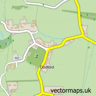
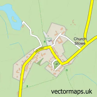
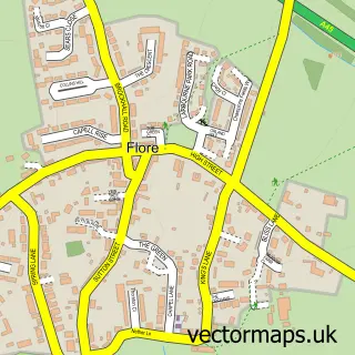
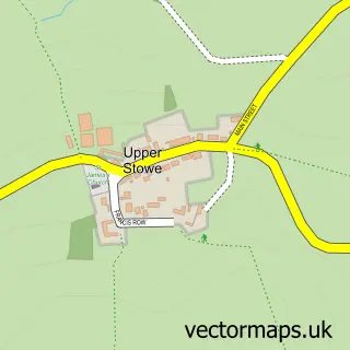
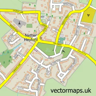
This Weedon Bec street map is a detailed vector street map covering a 750m x 750m area. Select a larger area to create and download your own vector street map of Weedon Bec.

Weedon Bec is a village in Northamptonshire, in the East Midlands of England. The settlement falls within the Daventry parliamentary constituency. It is served by the NN7 postcode district, with NN7 4 as the local postcode sector.

The 750-metre map sample for Weedon Bec covers 364 mapped buildings and approximately 21.7 km of road detail, of which 23 named roads are named. The immediate area includes 1 school, 1 GP surgery, 2 pubs and 1 MOT station within 2 miles. The wider area around Weedon Bec features 1 tourism point of interest and 3 food and drink venues. To create a larger or custom map of Weedon Bec, the map builder lets you define your own coverage area and download editable SVG, PDF and PNG files.

364Buildings
21.69 kmRoads
23Named roads
2,165Residents within 2 miles
Create your own

Create a larger editable map of Weedon Bec

Choose any area you need and generate a high-quality vector map instantly. Perfect for print, planning, design, business and personal use.

Choose any location
Editable SVG files
Any size up to A0
PDF, PNG & more
Instant download
High quality guaranteed
Create My Custom Map
Secure, private & no credit card required
Weedon Bec Vector Street Map
750m Sample
Weedon Bec vector street map sample showing roads, buildings and local features in a 750 metre preview area
Buy Weedon Bec Map Print from £12.95 Buy Weedon Bec Digital Map from £6

This Weedon Bec street map in Northamptonshire is available as downloadable SVG, PDF and PNG map files, or as a printed map for planning, business, display, education, local information and design work. You can also create a larger custom map area using the map selector.

What this Weedon Bec map sample shows

Weedon Bec lies within Weedon Bec Cp parish, part of Weedon ward in the West Northamptonshire local authority area. The postcode geography for this area includes the NN postcode area, the NN7 postcode district and the NN7 4 postcode sector. Residents fall under the Nhs Northamptonshire Integrated Care Board for NHS services.

Local features near Weedon Bec

Within 2 miles

Amenities and services in and around Weedon Bec.

1 Schools
1 GP surgeries 1 within 2 miles
1 MOT stations within 2 miles
1 Tourism & leisure
3 Food & drink
2 Pubs
2 Healthcare POIs
2 Vehicle services

Counts are approximate and based on publicly available data.

Administrative and postcode information for Weedon Bec

Weedon Bec lies within Weedon Bec Cp parish, part of Weedon ward in the West Northamptonshire local authority area. The postcode geography for this area includes the NN postcode area, the NN7 postcode district and the NN7 4 postcode sector. Residents fall under the Nhs Northamptonshire Integrated Care Board for NHS services.

Parish Weedon Bec CP
Ward Weedon
District / local authority West Northamptonshire
County Northamptonshire
Historic county Northamptonshire
Postcode district NN7
Postcode sector NN7 4
Parliamentary constituency Daventry
Region East Midlands
Country England

Nearby street map samples around Weedon Bec

Street map sample of Daventry, Northamptonshire Daventry Town - Northamptonshire - 3.9 miles Street map sample of Milton Keynes, Buckinghamshire Milton Keynes City - Buckinghamshire - 18.9 miles Street map sample of Dodford, Northamptonshire Dodford Village - Northamptonshire - 1.1 miles Street map sample of Church Stowe, Northamptonshire Church Stowe Village - Northamptonshire - 1.3 miles Street map sample of Flore, Northamptonshire Flore Village - Northamptonshire - 1.4 miles Street map sample of Upper Stowe, Northamptonshire Upper Stowe Village - Northamptonshire - 2.0 miles Street map sample of Nether Heyford, Northamptonshire Nether Heyford Village - Northamptonshire - 2.2 miles Street map sample of Everdon, Northamptonshire Everdon Village - Northamptonshire - 2.2 miles Street map sample of Brockhall, Northamptonshire Brockhall Village - Northamptonshire - 2.2 miles Street map sample of Upper Heyford, Northamptonshire Upper Heyford Village - Northamptonshire - 2.4 miles

More street maps in Northamptonshire

Street map sample of Dodford, Northamptonshire Dodford Village - 1.1 miles Street map sample of Church Stowe, Northamptonshire Church Stowe Village - 1.3 miles Street map sample of Flore, Northamptonshire Flore Village - 1.4 miles Street map sample of Upper Stowe, Northamptonshire Upper Stowe Village - 2.0 miles Street map sample of Nether Heyford, Northamptonshire Nether Heyford Village - 2.2 miles

750 metre map area coverage

Boundary, postcode and point of interest information for the 750m x 750m rectangle centred on this sample map.

Boundaries containing map centre

Constituency: Daventry Co Const

District: West Northamptonshire

Icb: NHS Northamptonshire ICB

Parish: Weedon Bec CP

Police Force: northamptonshire

Postcode District: NN7

Postcode Sector: NN7 4

Ward: Woodford & Weedon Ward

Nearby boundaries intersecting sample

No additional intersecting boundaries found.

Postcode coverage

NN7 NN7 4

POI category counts

Arts And Entertainment: 2

Automotive Repair: 2

Contractor: 2

Doctor: 2

Elementary School: 2

Gym: 2

Gymnastics Center: 2

Pub: 2

Accommodation: 1

Advertising Agency: 1

Sample points of interest

  • Riverside Court Accommodation
  • Simply Online Marketing Advertising Agency
  • RiverKnits Arts And Crafts
  • Set Connection Arts And Entertainment
  • The Sanctuary Arts And Entertainment
  • Floatingtraders Automotive
  • BaggedBenzUK Automotive Repair
  • Red-R Performance Automotive Repair
  • Papillon Cakes Bakery
  • Man Up Barber
  • Peter Rose Bathrooms Bathroom Remodeling
  • Amy's Mobile Hairdressing Beauty Product Supplier

Create a larger editable map of Weedon Bec

This sample shows only a 750 metre area. To create a larger map of Weedon Bec, use our map builder to choose your own coverage area, add titles and download editable SVG, PDF and PNG files.

Create a custom map of Weedon Bec

Phone 01751 473136 | Copyright Vectormaps.uk 2026

Samples Customizer Privacy Disclaimer
Weedon Bec Vector Street Map
Weedon Bec enlarged street map sample showing a 750 metre preview area