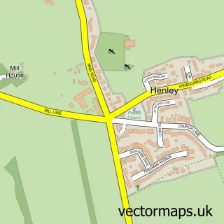
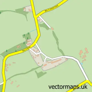
This Westerfield street map is a detailed vector street map covering a 750m x 750m area. Select a larger area to create and download your own vector street map of Westerfield.
The 750-metre map sample for Westerfield covers 197 mapped buildings and approximately 10.1 km of road detail, of which 7 named roads are named. The immediate area includes 5 GP surgeries within 2 miles, 3 pubs and 9 MOT stations within 2 miles. The wider area around Westerfield features 3 food and drink venues and 1 campsite within 2 miles. To create a larger or custom map of Westerfield, the map builder lets you define your own coverage area and download editable SVG, PDF and PNG files.
Create a larger editable map of Westerfield
Choose any area you need and generate a high-quality vector map instantly. Perfect for print, planning, design, business and personal use.

This Westerfield street map in Suffolk is available as downloadable SVG, PDF and PNG map files, or as a printed map for planning, business, display, education, local information and design work. You can also create a larger custom map area using the map selector.
What this Westerfield map sample shows
Westerfield lies within Westerfield Cp parish, part of Carlford & Fynn Valley ward in the East Suffolk District local authority area. The postcode geography for this area includes the IP postcode area, the IP6 postcode district and the IP6 9 postcode sector. Residents fall under the Nhs Suffolk And North East Essex Integrated Care Board for NHS services.
Local features near Westerfield
Within 2 milesAmenities and services in and around Westerfield.
Administrative and postcode information for Westerfield
Westerfield lies within Westerfield Cp parish, part of Carlford & Fynn Valley ward in the East Suffolk District local authority area. The postcode geography for this area includes the IP postcode area, the IP6 postcode district and the IP6 9 postcode sector. Residents fall under the Nhs Suffolk And North East Essex Integrated Care Board for NHS services.
Nearby street map samples around Westerfield

More street maps in Suffolk
750 metre map area coverage
Boundary, postcode and point of interest information for the 750m x 750m rectangle centred on this sample map.
Boundaries containing map centre
Constituency: Central Suffolk and North Ipswich Co Const
County: Suffolk County
District: East Suffolk District
Icb: NHS Essex ICB
Parish: Westerfield CP
Police Force: suffolk
Postcode District: IP6
Postcode Sector: IP6 9
Ward: Carlford & Fynn Valley Ward
Nearby boundaries intersecting sample
No additional intersecting boundaries found.
Postcode coverage
POI category counts
Pub: 3
Home Health Care: 2
Professional Services: 2
Anglican Church: 1
Assisted Living Facility: 1
Beauty Salon: 1
Building Contractor: 1
Business Office Supplies And Stationery: 1
Carpet Cleaning: 1
Counseling And Mental Health: 1
Sample points of interest
- St Mary Magdalene
- Cambian Group
- Yourbeauty by megan
- Harrison & Wildon Ltd.
- Thompson Page
- Payne & Son
- Jamie Clarke Counselling
- Espoir School of Dance
- Westerfield Business Centre
- Sharward Services
- Hollycroft Financial Mangement
- Beyea Care
Create a larger editable map of Westerfield
This sample shows only a 750 metre area. To create a larger map of Westerfield, use our map builder to choose your own coverage area, add titles and download editable SVG, PDF and PNG files.
Create a custom map of Westerfield