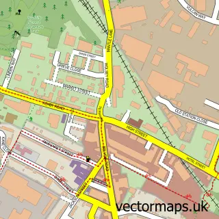
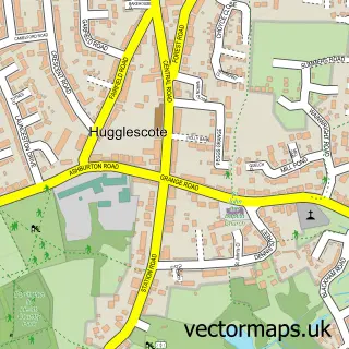
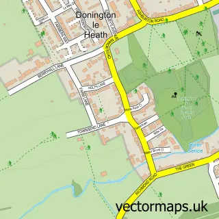
This Whitwick street map is a detailed vector street map covering a 750m x 750m area. Select a larger area to create and download your own vector street map of Whitwick.
The 750-metre map sample for Whitwick covers 452 mapped buildings and approximately 21.1 km of road detail, of which 29 named roads are named. The immediate area includes 2 GP surgeries, with 5 within 2 miles, 8 pubs and 2 MOT stations, with 13 within 2 miles. The wider area around Whitwick features 1 tourism point of interest, 11 food and drink venues and 1 campsite within 2 miles. To create a larger or custom map of Whitwick, the map builder lets you define your own coverage area and download editable SVG, PDF and PNG files.
Create a larger editable map of Whitwick
Choose any area you need and generate a high-quality vector map instantly. Perfect for print, planning, design, business and personal use.

This Whitwick street map in Leicestershire is available as downloadable SVG, PDF and PNG map files, or as a printed map for planning, business, display, education, local information and design work. You can also create a larger custom map area using the map selector.
What this Whitwick map sample shows
Whitwick lies within Whitwick Cp parish, part of Hermitage ward in the North West Leicestershire District local authority area. The postcode geography for this area includes the LE postcode area, the LE67 postcode district and the LE67 5 postcode sector. Residents fall under the Nhs Leicester, Leicestershire And Rutland Integrated Care Board for NHS services.
Local features near Whitwick
Within 2 milesAmenities and services in and around Whitwick.
Administrative and postcode information for Whitwick
The local authority covering Whitwick is North West Leicestershire District, within the county of Leicestershire. The settlement lies within Hermitage ward and Whitwick Cp civil parish. The LE67 postcode district and LE67 5 postcode sector serve the immediate area. NHS provision in the area is delivered through University Hospitals Of Leicester Nhs Trust.
Nearby street map samples around Whitwick

More street maps in Leicestershire
750 metre map area coverage
Boundary, postcode and point of interest information for the 750m x 750m rectangle centred on this sample map.
Boundaries containing map centre
Constituency: North West Leicestershire Co Const
County: Leicestershire County
District: North West Leicestershire District
Icb: NHS Leicester Leicestershire and Rutland ICB
Parish: Whitwick CP
Police Force: leicestershire
Postcode District: LE67
Postcode Sector: LE67 5
Nearby boundaries intersecting sample
Ward: Hermitage Ward, Holly Hayes Ward, Thornborough Ward
Postcode coverage
POI category counts
Pub: 8
Medical Center: 4
Building Supply Store: 3
Hair Salon: 3
Post Office: 3
Social Service Organizations: 3
Atms: 2
Beauty And Spa: 2
Beauty Salon: 2
Convenience Store: 2
Sample points of interest
- Totally Balanced Ltd
- Whitwick: St John the Baptist
- Central England Co-Op - Whitwick, Whitwick
- PayPoint
- Castle Garage
- KCR Service and MOT Centre
- Whitwick Baptist Church
- Hair By Chloe Tarry
- Saint Rose
- Nails by Stacy
- The Beauty Station
- Avant-garde Home Design
Create a larger editable map of Whitwick
This sample shows only a 750 metre area. To create a larger map of Whitwick, use our map builder to choose your own coverage area, add titles and download editable SVG, PDF and PNG files.
Create a custom map of Whitwick