This Wrington street map is a detailed vector street map covering a 750m x 750m area. Select a larger area to create and download your own vector street map of Wrington.
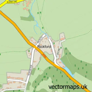
The 750-metre map sample for Wrington covers 439 mapped buildings and approximately 14.4 km of road detail, of which 35 named roads are named. The immediate area includes 1 school, 1 GP surgery within 2 miles, 3 pubs and 1 MOT station. The wider area around Wrington features 4 food and drink venues and 1 campsite within 2 miles. To create a larger or custom map of Wrington, the map builder lets you define your own coverage area and download editable SVG, PDF and PNG files.
Create a larger editable map of Wrington
Choose any area you need and generate a high-quality vector map instantly. Perfect for print, planning, design, business and personal use.

This Wrington street map in Somerset is available as downloadable SVG, PDF and PNG map files, or as a printed map for planning, business, display, education, local information and design work. You can also create a larger custom map area using the map selector.
What this Wrington map sample shows
Wrington lies within Wrington Cp parish, part of Wrington ward in the North Somerset local authority area. The postcode geography for this area includes the BS postcode area, the BS40 postcode district and the BS40 5 postcode sector. Residents fall under the Nhs Bristol, North Somerset And South Gloucestershire Integrated Care Board for NHS services.
Local features near Wrington
Within 2 milesAmenities and services in and around Wrington.
Administrative and postcode information for Wrington
Wrington lies within Wrington Cp parish, part of Wrington ward in the North Somerset local authority area. The postcode geography for this area includes the BS postcode area, the BS40 postcode district and the BS40 5 postcode sector. Residents fall under the Nhs Bristol, North Somerset And South Gloucestershire Integrated Care Board for NHS services.
Nearby street map samples around Wrington

More street maps in Somerset
750 metre map area coverage
Boundary, postcode and point of interest information for the 750m x 750m rectangle centred on this sample map.
Boundaries containing map centre
Constituency: North Somerset Co Const
District: North Somerset
Icb: NHS Bristol North Somerset and South Gloucestershire ICB
Parish: Wrington CP
Police Force: avon and somerset
Postcode District: BS40
Postcode Sector: BS40 5
Ward: Wrington Ward
Nearby boundaries intersecting sample
No additional intersecting boundaries found.
Postcode coverage
POI category counts
Flowers And Gifts Shop: 3
Pub: 3
School: 3
Bar: 2
Beauty Salon: 2
Contractor: 2
Convenience Store: 2
Financial Advising: 2
Home Goods Store: 2
Scout Hall: 2
Sample points of interest
- Wrington Village
- Dan Lloyd Acupuncturist
- Avalon Assessments Ltd
- Wrington Redhill FC
- All Saints
- Belle Torte
- NatWest
- NatWest
- BarBah Mobile Bar Hire
- The Rec Bar Wrington
- Jack's Barbershop
- The Salon at Railway Wharf
Create a larger editable map of Wrington
This sample shows only a 750 metre area. To create a larger map of Wrington, use our map builder to choose your own coverage area, add titles and download editable SVG, PDF and PNG files.
Create a custom map of Wrington