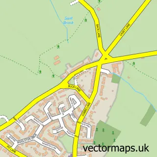
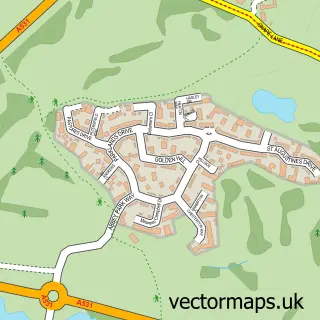
This Wybunbury street map is a detailed vector street map covering a 750m x 750m area. Select a larger area to create and download your own vector street map of Wybunbury.
The 750-metre map sample for Wybunbury covers 140 mapped buildings and approximately 5.3 km of road detail, of which 9 named roads are named. The immediate area includes 1 GP surgery within 2 miles, 3 pubs and 5 MOT stations within 2 miles. The wider area around Wybunbury features 1 tourism point of interest and 3 food and drink venues. To create a larger or custom map of Wybunbury, the map builder lets you define your own coverage area and download editable SVG, PDF and PNG files.
Create a larger editable map of Wybunbury
Choose any area you need and generate a high-quality vector map instantly. Perfect for print, planning, design, business and personal use.

This Wybunbury street map in Cheshire is available as downloadable SVG, PDF and PNG map files, or as a printed map for planning, business, display, education, local information and design work. You can also create a larger custom map area using the map selector.
What this Wybunbury map sample shows
Wybunbury lies within Wybunbury Cp parish, part of Wybunbury ward in the Cheshire East (B) local authority area. The postcode geography for this area includes the CW postcode area, the CW5 postcode district and the CW5 7 postcode sector. Residents fall under the Nhs Cheshire And Merseyside Integrated Care Board for NHS services.
Local features near Wybunbury
Within 2 milesAmenities and services in and around Wybunbury.
Administrative and postcode information for Wybunbury
Wybunbury lies within Wybunbury Cp parish, part of Wybunbury ward in the Cheshire East (B) local authority area. The postcode geography for this area includes the CW postcode area, the CW5 postcode district and the CW5 7 postcode sector. Residents fall under the Nhs Cheshire And Merseyside Integrated Care Board for NHS services.
Nearby street map samples around Wybunbury

More street maps in Cheshire
750 metre map area coverage
Boundary, postcode and point of interest information for the 750m x 750m rectangle centred on this sample map.
Boundaries containing map centre
Constituency: Chester South and Eddisbury Co Const
District: Cheshire East (B)
Icb: NHS Cheshire and Merseyside ICB
Parish: Wybunbury CP
Police Force: cheshire
Postcode District: CW5
Postcode Sector: CW5 7
Ward: Wybunbury Ward
Nearby boundaries intersecting sample
Parish: Hough and Chorlton CP, Walgherton CP
Postcode coverage
POI category counts
Pub: 3
Business Management Services: 2
Anglican Church: 1
Architectural Designer: 1
Beauty Salon: 1
Brewery: 1
Business Advertising: 1
Church Cathedral: 1
Community Center: 1
Currency Exchange: 1
Sample points of interest
- St Chad's, Wybunbury
- Lines 2 Designs
- The Derma Clinic
- Frederic Robinson Limited
- MSCopy-Editing
- Post Office-Wybunbury
- Wybunbury Post Office
- St Chad's Church
- Wybunbury Village Hall
- Post Office Travel Money
- Red Lion Wybunbury 2014
- Sparklean
Create a larger editable map of Wybunbury
This sample shows only a 750 metre area. To create a larger map of Wybunbury, use our map builder to choose your own coverage area, add titles and download editable SVG, PDF and PNG files.
Create a custom map of Wybunbury