Vector Maps logo
Home Why it works Popular maps Districts Samples Customizer Create Your Map
VectorMaps.uk
Home Popular maps Districts Samples Customizer Create Your Map Privacy Disclaimer
Home / UK Maps / Inverness / Arisaig Map

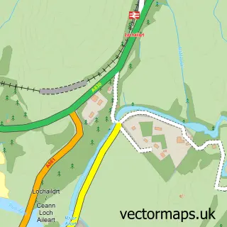
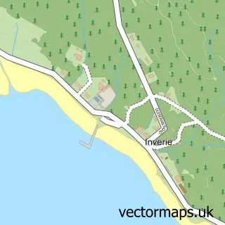
This Arisaig street map is a detailed vector street map covering a 750m x 750m area. Select a larger area to create and download your own vector street map of Arisaig.

Arisaig is a village in Inverness, in the Highlands And Islands of Scotland. Historically, the area formed part of Inverness-Shire. The settlement falls within the Ross, Skye And Lochaber parliamentary constituency. It is served by the PH39 postcode distr

The 750-metre map sample for Arisaig covers 64 mapped buildings and approximately 13.3 km of road detail, of which 2 named roads are named. The immediate area includes 1 railway station. The wider area around Arisaig features 1 tourism point of interest, 1 food and drink venue and 3 hotels. To create a larger or custom map of Arisaig, the map builder lets you define your own coverage area and download editable SVG, PDF and PNG files.

64Buildings
13.25 kmRoads
2Named roads
0Residents within 2 miles
Create your own

Create a larger editable map of Arisaig

Choose any area you need and generate a high-quality vector map instantly. Perfect for print, planning, design, business and personal use.

Choose any location
Editable SVG files
Any size up to A0
PDF, PNG & more
Instant download
High quality guaranteed
Create My Custom Map
Secure, private & no credit card required
Arisaig Vector Street Map
750m Sample
Arisaig vector street map sample showing roads, buildings and local features in a 750 metre preview area
Buy Arisaig Map Print from £12.95 Buy Arisaig Digital Map from £6

This Arisaig street map in Inverness is available as downloadable SVG, PDF and PNG map files, or as a printed map for planning, business, display, education, local information and design work. You can also create a larger custom map area using the map selector.

What this Arisaig map sample shows

Arisaig lies within Highland parish, part of Caol And Mallaig ward in the Highland local authority area. The postcode geography for this area includes the PH postcode area, the PH39 postcode district and the PH39 4 postcode sector. Residents fall under the Highland for NHS services.

Local features near Arisaig

Within 2 miles

Amenities and services in and around Arisaig.

1 Railway stations
1 Campsites within 2 miles
1 Tourism & leisure
1 Food & drink
3 Hotels

Counts are approximate and based on publicly available data.

Administrative and postcode information for Arisaig

The local authority covering Arisaig is Highland, within the county of Inverness. The settlement lies within Caol And Mallaig ward and Highland civil parish. The PH39 postcode district and PH39 4 postcode sector serve the immediate area. NHS provision in the area is delivered through Highland.

Parish HIGHLAND
Ward Caol and Mallaig
District / local authority Highland
County Inverness
Historic county Inverness-shire
Postcode district PH39
Postcode sector PH39 4
Parliamentary constituency Ross, Skye and Lochaber
Region Highlands and Islands
Country Scotland

Nearby street map samples around Arisaig

Street map sample of Tobermory, Argyll and Bute Tobermory Town - Argyll and Bute - 21.6 miles Street map sample of Inverness, Inverness Inverness City - Inverness - 72.2 miles Street map sample of Mòrar, Inverness Mòrar Village - Inverness - 4.2 miles Street map sample of Glenuig, Inverness Glenuig Village - Inverness - 5.8 miles Street map sample of Mallaig, Inverness Mallaig Village - Inverness - 6.6 miles Street map sample of Lochailort, Inverness Lochailort Village - Inverness - 7.1 miles Street map sample of Àird Shlèite, Ross and Cromarty Àird Shlèite Village - Ross and Cromarty - 9.6 miles Street map sample of Cailigearraidh, Ross and Cromarty Cailigearraidh Village - Ross and Cromarty - 10.5 miles Street map sample of Àird a' Bhàsair, Ross and Cromarty Àird a' Bhàsair Village - Ross and Cromarty - 10.6 miles Street map sample of Inverie, Inverness Inverie Village - Inverness - 10.6 miles

More street maps in Inverness

Street map sample of Mòrar, Inverness Mòrar Village - 4.2 miles Street map sample of Glenuig, Inverness Glenuig Village - 5.8 miles Street map sample of Mallaig, Inverness Mallaig Village - 6.6 miles Street map sample of Lochailort, Inverness Lochailort Village - 7.1 miles Street map sample of Inverie, Inverness Inverie Village - 10.6 miles

750 metre map area coverage

Boundary, postcode and point of interest information for the 750m x 750m rectangle centred on this sample map.

Boundaries containing map centre

Constituency: Inverness, Skye and West Ross-shire Co Const

District: Highland

Icb: Highland

Postcode District: PH39

Postcode Sector: PH39 4

Ward: Caol and Mallaig Ward

Nearby boundaries intersecting sample

No additional intersecting boundaries found.

Postcode coverage

PH39 PH39 4

POI category counts

Hotel: 3

Train Station: 3

Convenience Store: 2

Cottage: 2

Archery Range: 1

Bar: 1

Cafe: 1

Canoe And Kayak Hire Service: 1

Catholic Church: 1

Church Cathedral: 1

Sample points of interest

  • Arisaig Archery Archery Range
  • The Crofters Rest Bar
  • Sound Bites Cafe
  • Arisaig Sea Kayak Centre Canoe And Kayak Hire Service
  • North West Lochaber Catholic Church
  • Lighthouse Church Arisaig Church Cathedral
  • Astley Hall Community Services Non Profits
  • Arisaig Stores Convenience Store
  • SPAR Arisaig Convenience Store
  • Brae Hoose Holiday Cottage, Arisaig Cottage
  • Rhu Cottage Cottage
  • Arisaig Gundogs Dog Trainer

Create a larger editable map of Arisaig

This sample shows only a 750 metre area. To create a larger map of Arisaig, use our map builder to choose your own coverage area, add titles and download editable SVG, PDF and PNG files.

Create a custom map of Arisaig

Phone 01751 473136 | Copyright Vectormaps.uk 2026

Samples Customizer Privacy Disclaimer
Arisaig Vector Street Map
Arisaig enlarged street map sample showing a 750 metre preview area