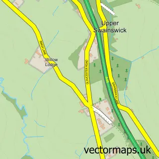
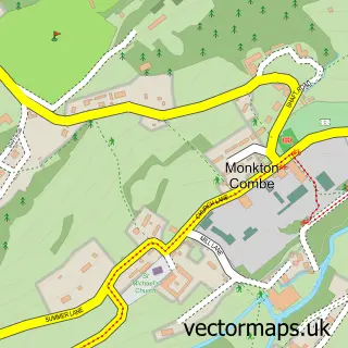
This Batheaston street map is a detailed vector street map covering a 750m x 750m area. Select a larger area to create and download your own vector street map of Batheaston.
The 750-metre map sample for Batheaston covers 259 mapped buildings and approximately 10.0 km of road detail, of which 15 named roads are named. The immediate area includes 1 GP surgery, with 3 within 2 miles, 2 pubs and 3 MOT stations within 2 miles. The wider area around Batheaston features 5 tourism points of interest, 4 food and drink venues and 1 hotel. To create a larger or custom map of Batheaston, the map builder lets you define your own coverage area and download editable SVG, PDF and PNG files.
Create a larger editable map of Batheaston
Choose any area you need and generate a high-quality vector map instantly. Perfect for print, planning, design, business and personal use.

This Batheaston street map in Somerset is available as downloadable SVG, PDF and PNG map files, or as a printed map for planning, business, display, education, local information and design work. You can also create a larger custom map area using the map selector.
What this Batheaston map sample shows
Batheaston lies within Bathford Cp parish, part of Bathavon North ward in the Bath And North East Somerset local authority area. The postcode geography for this area includes the BA postcode area, the BA1 postcode district and the BA1 7 postcode sector. Residents fall under the Nhs Bath And North East Somerset, Swindon And Wiltshire Integrated Care Board for NHS services.
Local features near Batheaston
Within 2 milesAmenities and services in and around Batheaston.
Administrative and postcode information for Batheaston
The local authority covering Batheaston is Bath And North East Somerset, within the county of Somerset. The settlement lies within Bathavon North ward and Bathford Cp civil parish. The BA1 postcode district and BA1 7 postcode sector serve the immediate area. NHS provision in the area is delivered through Royal United Hospitals Bath Nhs Foundation Trust.
Nearby street map samples around Batheaston

More street maps in Somerset
750 metre map area coverage
Boundary, postcode and point of interest information for the 750m x 750m rectangle centred on this sample map.
Boundaries containing map centre
Constituency: Bath Co Const
District: Bath and North East Somerset
Icb: NHS Bath and North East Somerset Swindon and Wiltshire ICB
Parish: Batheaston CP
Police Force: avon and somerset
Postcode District: BA1
Postcode Sector: BA1 7
Ward: Bathavon North Ward
Nearby boundaries intersecting sample
Parish: Bathampton CP, Bathford CP
Postcode District: BA2
Postcode Sector: BA2 6
Postcode coverage
POI category counts
Convenience Store: 3
Pharmacy: 3
Post Office: 3
Attractions And Activities: 2
Beauty Product Supplier: 2
Bed And Breakfast: 2
Cafe: 2
Fashion Accessories Store: 2
Food Delivery Service: 2
Hair Salon: 2
Sample points of interest
- Batheaston Bookkeeping
- St Johns Ambulance
- Piccadilly Antiques
- Batheaston Convenience Store (Link DC), Batheaston
- Bathampton Meadows
- Launch Point Adventures
- J J's Hair Design
- Jj's Hair And Beauty
- Karen Silk hairdressing
- Dolphin House
- Poplar House
- Aquadri Pest Control Bath
Create a larger editable map of Batheaston
This sample shows only a 750 metre area. To create a larger map of Batheaston, use our map builder to choose your own coverage area, add titles and download editable SVG, PDF and PNG files.
Create a custom map of Batheaston