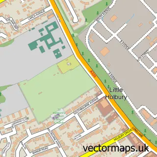
This Blackfield street map is a detailed vector street map covering a 750m x 750m area. Select a larger area to create and download your own vector street map of Blackfield.
The 750-metre map sample for Blackfield covers 532 mapped buildings and approximately 18.5 km of road detail, of which 33 named roads are named. The immediate area includes 1 school and 1 MOT station, with 6 within 2 miles. The wider area around Blackfield features 4 food and drink venues and 1 campsite within 2 miles. To create a larger or custom map of Blackfield, the map builder lets you define your own coverage area and download editable SVG, PDF and PNG files.
Create a larger editable map of Blackfield
Choose any area you need and generate a high-quality vector map instantly. Perfect for print, planning, design, business and personal use.

This Blackfield street map in Hampshire is available as downloadable SVG, PDF and PNG map files, or as a printed map for planning, business, display, education, local information and design work. You can also create a larger custom map area using the map selector.
What this Blackfield map sample shows
Blackfield lies within Fawley Cp parish, part of Fawley, Blackfield And Langley ward in the New Forest District local authority area. The postcode geography for this area includes the SO postcode area, the SO45 postcode district and the SO45 1 postcode sector. Residents fall under the Nhs Hampshire And Isle Of Wight Integrated Care Board for NHS services.
Local features near Blackfield
Within 2 milesAmenities and services in and around Blackfield.
Administrative and postcode information for Blackfield
The local authority covering Blackfield is New Forest District, within the county of Hampshire. The settlement lies within Fawley, Blackfield And Langley ward and Fawley Cp civil parish. The SO45 postcode district and SO45 1 postcode sector serve the immediate area. NHS provision in the area is delivered through University Hospital Southampton Nhs Foundation Trust.
Nearby street map samples around Blackfield


More street maps in Hampshire
750 metre map area coverage
Boundary, postcode and point of interest information for the 750m x 750m rectangle centred on this sample map.
Boundaries containing map centre
Constituency: New Forest East Co Const
County: Hampshire County
District: New Forest District
Icb: NHS Hampshire and Isle of Wight ICB
Parish: Fawley CP
Police Force: hampshire
Postcode District: SO45
Postcode Sector: SO45 1
Ward: Fawley, Blackfield, Calshot & Langley Ward
Nearby boundaries intersecting sample
Ward: Hardley, Holbury & North Blackfield Ward
Postcode coverage
POI category counts
Bakery: 2
Barber: 2
Beauty Salon: 2
Cafe: 2
Charity Organization: 2
Clothing Store: 2
Coffee Shop: 2
Convenience Store: 2
Dance Wear: 2
Fish And Chips Restaurant: 2
Sample points of interest
- Purlessence
- Pinfolds Mechanical
- Blackfield Garage Services
- Blackfield Baker L.T.D.
- The Blackfield Baker
- Lloyds Bank
- Leo's Barber
- Ron The Barber
- Harts & Mortons Hair & Beauty ltd
- Lavish Locks
- A & S Painting Services
- Broadview Consultancy And Training Ltd.
Create a larger editable map of Blackfield
This sample shows only a 750 metre area. To create a larger map of Blackfield, use our map builder to choose your own coverage area, add titles and download editable SVG, PDF and PNG files.
Create a custom map of Blackfield