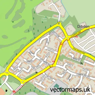
This Hythe street map is a detailed vector street map covering a 750m x 750m area. Select a larger area to create and download your own vector street map of Hythe.
The 750-metre map sample for Hythe covers 276 mapped buildings and approximately 13.8 km of road detail, of which 34 named roads are named. The immediate area includes 1 school, 1 GP surgery, with 4 within 2 miles, 2 pubs and 1 MOT station, with 6 within 2 miles. The wider area around Hythe features 8 tourism points of interest, 11 food and drink venues and 1 hotel. To create a larger or custom map of Hythe, the map builder lets you define your own coverage area and download editable SVG, PDF and PNG files.
Create a larger editable map of Hythe
Choose any area you need and generate a high-quality vector map instantly. Perfect for print, planning, design, business and personal use.

This Hythe street map in Hampshire is available as downloadable SVG, PDF and PNG map files, or as a printed map for planning, business, display, education, local information and design work. You can also create a larger custom map area using the map selector.
What this Hythe map sample shows
Hythe lies within Hythe And Dibden Cp parish, part of Hythe West And Langdown ward in the New Forest District local authority area. The postcode geography for this area includes the SO postcode area, the SO45 postcode district and the SO45 6 postcode sector. Residents fall under the Nhs Hampshire And Isle Of Wight Integrated Care Board for NHS services.
Local features near Hythe
Within 2 milesAmenities and services in and around Hythe.
Administrative and postcode information for Hythe
Hythe lies within Hythe And Dibden Cp parish, part of Hythe West And Langdown ward in the New Forest District local authority area. The postcode geography for this area includes the SO postcode area, the SO45 postcode district and the SO45 6 postcode sector. Residents fall under the Nhs Hampshire And Isle Of Wight Integrated Care Board for NHS services.
Nearby street map samples around Hythe


More street maps in Hampshire
750 metre map area coverage
Boundary, postcode and point of interest information for the 750m x 750m rectangle centred on this sample map.
Boundaries containing map centre
Constituency: New Forest East Co Const
County: Hampshire County
District: New Forest District
Icb: NHS Hampshire and Isle of Wight ICB
Parish: Hythe and Dibden CP
Police Force: hampshire
Postcode District: SO45
Postcode Sector: SO45 6
Ward: Hythe Central Ward
Nearby boundaries intersecting sample
Postcode Sector: SO45 5
Ward: Hythe South Ward
Postcode coverage
POI category counts
Charity Organization: 7
Real Estate Agent: 7
Advertising Agency: 5
Banks: 5
Cafe: 5
Beauty Salon: 4
Church Cathedral: 4
Flowers And Gifts Shop: 4
Gym: 4
Hair Salon: 4
Sample points of interest
- Certax Accounting (New Forest) Ltd.
- Maples Bookkeeping Services
- FIMA Digital
- Fate Promotions Ltd.
- Im-press Promotions Southampton
- Pink Wahoo
- Zap Creative
- St John the Baptist
- 1MoreRoom.co.uk
- IHD Architectural Services
- Gallery 68
- Fully Woolly
Create a larger editable map of Hythe
This sample shows only a 750 metre area. To create a larger map of Hythe, use our map builder to choose your own coverage area, add titles and download editable SVG, PDF and PNG files.
Create a custom map of Hythe