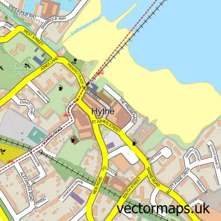
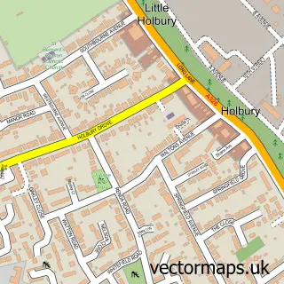
This Dibden street map is a detailed vector street map covering a 750m x 750m area. Select a larger area to create and download your own vector street map of Dibden.
The 750-metre map sample for Dibden covers 226 mapped buildings and approximately 13.0 km of road detail, of which 26 named roads are named. The immediate area includes 1 school, 3 GP surgeries within 2 miles and 5 MOT stations within 2 miles. The wider area around Dibden features 1 tourism point of interest. To create a larger or custom map of Dibden, the map builder lets you define your own coverage area and download editable SVG, PDF and PNG files.
Create a larger editable map of Dibden
Choose any area you need and generate a high-quality vector map instantly. Perfect for print, planning, design, business and personal use.

This Dibden street map in Hampshire is available as downloadable SVG, PDF and PNG map files, or as a printed map for planning, business, display, education, local information and design work. You can also create a larger custom map area using the map selector.
What this Dibden map sample shows
Dibden lies within Hythe And Dibden Cp parish, part of Hythe West And Langdown ward in the New Forest District local authority area. The postcode geography for this area includes the SO postcode area, the SO45 postcode district and the SO45 5 postcode sector. Residents fall under the Nhs Hampshire And Isle Of Wight Integrated Care Board for NHS services.
Local features near Dibden
Within 2 milesAmenities and services in and around Dibden.
Administrative and postcode information for Dibden
The local authority covering Dibden is New Forest District, within the county of Hampshire. The settlement lies within Hythe West And Langdown ward and Hythe And Dibden Cp civil parish. The SO45 postcode district and SO45 5 postcode sector serve the immediate area. NHS provision in the area is delivered through University Hospital Southampton Nhs Foundation Trust.
Nearby street map samples around Dibden


More street maps in Hampshire
750 metre map area coverage
Boundary, postcode and point of interest information for the 750m x 750m rectangle centred on this sample map.
Boundaries containing map centre
Constituency: New Forest East Co Const
County: Hampshire County
District: New Forest District
Icb: NHS Hampshire and Isle of Wight ICB
Parish: Hythe and Dibden CP
Police Force: hampshire
Postcode District: SO45
Postcode Sector: SO45 5
Ward: Dibden & Dibden Purlieu Ward
Nearby boundaries intersecting sample
No additional intersecting boundaries found.
Postcode coverage
POI category counts
Building Contractor: 2
Rental Kiosks: 2
Altering And Remodeling Contractor: 1
Auto Loan Provider: 1
Automotive: 1
Building Supply Store: 1
Car Wash: 1
Computer Store: 1
Counseling And Mental Health: 1
Dog Walkers: 1
Sample points of interest
- Elite Builders
- Helen Sparks Mortgages & Financial Services
- Shine And Go South
- S A B Groundworks
- Sab Groundworks
- M D Roofline Specialists
- Waves Hand Car Wash
- B & B Computer Services
- Inspire Counselling & Psychotherapy
- The Animal Angel
- Mark's Driving School
- New Forest Electrical
Create a larger editable map of Dibden
This sample shows only a 750 metre area. To create a larger map of Dibden, use our map builder to choose your own coverage area, add titles and download editable SVG, PDF and PNG files.
Create a custom map of Dibden