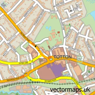
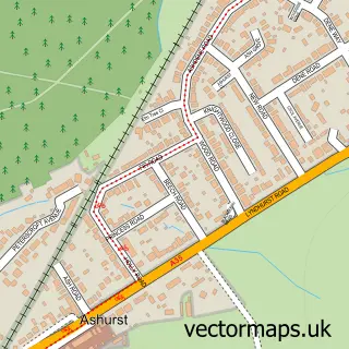
This Marchwood street map is a detailed vector street map covering a 750m x 750m area. Select a larger area to create and download your own vector street map of Marchwood.
The 750-metre map sample for Marchwood covers 481 mapped buildings and approximately 17.5 km of road detail, of which 41 named roads are named. The immediate area includes 1 school, 3 pubs and 19 MOT stations within 2 miles. The wider area around Marchwood features 1 tourism point of interest and 4 food and drink venues. To create a larger or custom map of Marchwood, the map builder lets you define your own coverage area and download editable SVG, PDF and PNG files.
Create a larger editable map of Marchwood
Choose any area you need and generate a high-quality vector map instantly. Perfect for print, planning, design, business and personal use.

This Marchwood street map in Hampshire is available as downloadable SVG, PDF and PNG map files, or as a printed map for planning, business, display, education, local information and design work. You can also create a larger custom map area using the map selector.
What this Marchwood map sample shows
Marchwood lies within Marchwood Cp parish, part of Marchwood ward in the New Forest District local authority area. The postcode geography for this area includes the SO postcode area, the SO40 postcode district and the SO40 4 postcode sector. Residents fall under the Nhs Hampshire And Isle Of Wight Integrated Care Board for NHS services.
Local features near Marchwood
Within 2 milesAmenities and services in and around Marchwood.
Administrative and postcode information for Marchwood
The local authority covering Marchwood is New Forest District, within the county of Hampshire. The settlement lies within Marchwood ward and Marchwood Cp civil parish. The SO40 postcode district and SO40 4 postcode sector serve the immediate area. NHS provision in the area is delivered through University Hospital Southampton Nhs Foundation Trust.
Nearby street map samples around Marchwood


More street maps in Hampshire
750 metre map area coverage
Boundary, postcode and point of interest information for the 750m x 750m rectangle centred on this sample map.
Boundaries containing map centre
Constituency: New Forest East Co Const
County: Hampshire County
District: New Forest District
Icb: NHS Hampshire and Isle of Wight ICB
Parish: Marchwood CP
Police Force: hampshire
Postcode District: SO40
Postcode Sector: SO40 4
Ward: Marchwood & Eling Ward
Nearby boundaries intersecting sample
No additional intersecting boundaries found.
Postcode coverage
POI category counts
Church Cathedral: 4
Plumbing: 4
Beauty Salon: 3
Convenience Store: 3
Pub: 3
Ambulance And Ems Services: 2
Arts And Entertainment: 2
Bakery: 2
Community Center: 2
Mortgage Broker: 2
Sample points of interest
- Criticare Ambulance Service
- Criticare UK Ambulance Service
- St John's Church, Marchwood and Eling Parish
- Clown Bluey
- The Uncorked Canvas Southampton
- ATM (Post Office)
- The Diesel Specialist
- D&D Artisan Bakery Southampton
- The Manna House Bakery
- Body And Soul Professional Beauty
- EMinence Skincare and Beauty
- The Beauty Lounge
Create a larger editable map of Marchwood
This sample shows only a 750 metre area. To create a larger map of Marchwood, use our map builder to choose your own coverage area, add titles and download editable SVG, PDF and PNG files.
Create a custom map of Marchwood