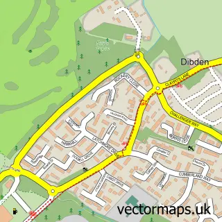
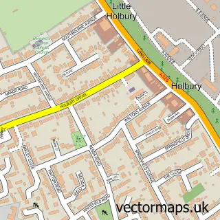
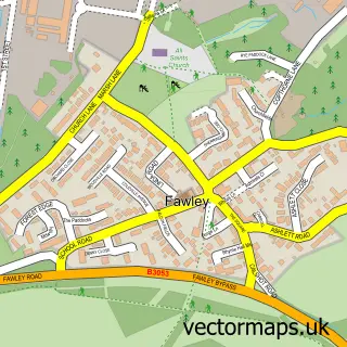
This Dibden Purlieu street map is a detailed vector street map covering a 750m x 750m area. Select a larger area to create and download your own vector street map of Dibden Purlieu.
The 750-metre map sample for Dibden Purlieu covers 619 mapped buildings and approximately 24.4 km of road detail, of which 36 named roads are named. The immediate area includes 1 GP surgery, with 3 within 2 miles, 3 pubs and 2 MOT stations, with 6 within 2 miles. The wider area around Dibden Purlieu features 2 tourism points of interest and 9 food and drink venues. To create a larger or custom map of Dibden Purlieu, the map builder lets you define your own coverage area and download editable SVG, PDF and PNG files.
Create a larger editable map of Dibden Purlieu
Choose any area you need and generate a high-quality vector map instantly. Perfect for print, planning, design, business and personal use.

This Dibden Purlieu street map in Hampshire is available as downloadable SVG, PDF and PNG map files, or as a printed map for planning, business, display, education, local information and design work. You can also create a larger custom map area using the map selector.
What this Dibden Purlieu map sample shows
Dibden Purlieu lies within Denny Lodge Cp parish, part of Brockenhurst And Forest South East ward in the New Forest District local authority area. The postcode geography for this area includes the SO postcode area, the SO45 postcode district and the SO45 4 postcode sector. Residents fall under the Nhs Hampshire And Isle Of Wight Integrated Care Board for NHS services.
Local features near Dibden Purlieu
Within 2 milesAmenities and services in and around Dibden Purlieu.
Administrative and postcode information for Dibden Purlieu
The local authority covering Dibden Purlieu is New Forest District, within the county of Hampshire. The settlement lies within Brockenhurst And Forest South East ward and Denny Lodge Cp civil parish. The SO45 postcode district and SO45 4 postcode sector serve the immediate area. NHS provision in the area is delivered through University Hospital Southampton Nhs Foundation Trust.
Nearby street map samples around Dibden Purlieu

More street maps in Hampshire
750 metre map area coverage
Boundary, postcode and point of interest information for the 750m x 750m rectangle centred on this sample map.
Boundaries containing map centre
Constituency: New Forest East Co Const
County: Hampshire County
District: New Forest District
Icb: NHS Hampshire and Isle of Wight ICB
Parish: Hythe and Dibden CP
Police Force: hampshire
Postcode District: SO45
Postcode Sector: SO45 4
Ward: Dibden & Dibden Purlieu Ward
Nearby boundaries intersecting sample
Parish: Denny Lodge CP
Postcode District: SO42
Postcode Sector: SO42 7
Ward: Brockenhurst & Denny Lodge Ward, Hythe South Ward
Postcode coverage
POI category counts
Beauty Salon: 4
Cafe: 3
Coffee Shop: 3
Hair Salon: 3
Pub: 3
Anglican Church: 2
Building Supply Store: 2
Education: 2
Gas Station: 2
Naturopathic Holistic: 2
Sample points of interest
- Rosa Hoola
- St Andrew's Church
- St Andrew's, Dibden Purlieu
- Coppice Gate - Retirement Living - McCarthy Stone
- Balmer Lawn Honda
- Shawfix Autos
- Lloyds Bank
- Lloyds Bank
- Gentlemen's Barbers Shop
- The Bathroom & Kitchen Academy
- Beauty Treatments by Sue J Nixon
- Danielle Jades Hairstylists
Create a larger editable map of Dibden Purlieu
This sample shows only a 750 metre area. To create a larger map of Dibden Purlieu, use our map builder to choose your own coverage area, add titles and download editable SVG, PDF and PNG files.
Create a custom map of Dibden Purlieu