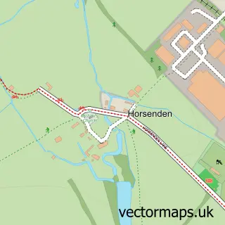
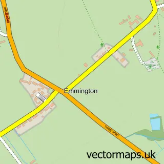
This Bledlow street map is a detailed vector street map covering a 750m x 750m area. Select a larger area to create and download your own vector street map of Bledlow.
The 750-metre map sample for Bledlow covers 105 mapped buildings and approximately 12.2 km of road detail, of which 5 named roads are named. The immediate area includes 1 GP surgery within 2 miles, 2 pubs and 4 MOT stations within 2 miles. The wider area around Bledlow features 2 tourism points of interest and 2 food and drink venues. To create a larger or custom map of Bledlow, the map builder lets you define your own coverage area and download editable SVG, PDF and PNG files.
Create a larger editable map of Bledlow
Choose any area you need and generate a high-quality vector map instantly. Perfect for print, planning, design, business and personal use.

This Bledlow street map in Buckinghamshire is available as downloadable SVG, PDF and PNG map files, or as a printed map for planning, business, display, education, local information and design work. You can also create a larger custom map area using the map selector.
What this Bledlow map sample shows
Bledlow lies within Bledlow-Cum-Saunderton Cp parish, part of Bledlow And Bradenham ward in the Buckinghamshire local authority area. The postcode geography for this area includes the HP postcode area, the HP27 postcode district and the HP27 9 postcode sector. Residents fall under the Nhs Buckinghamshire, Oxfordshire And Berkshire West Integrated Care Board for NHS services.
Local features near Bledlow
Within 2 milesAmenities and services in and around Bledlow.
Administrative and postcode information for Bledlow
Bledlow lies within Bledlow-Cum-Saunderton Cp parish, part of Bledlow And Bradenham ward in the Buckinghamshire local authority area. The postcode geography for this area includes the HP postcode area, the HP27 postcode district and the HP27 9 postcode sector. Residents fall under the Nhs Buckinghamshire, Oxfordshire And Berkshire West Integrated Care Board for NHS services.
Nearby street map samples around Bledlow


More street maps in Buckinghamshire
750 metre map area coverage
Boundary, postcode and point of interest information for the 750m x 750m rectangle centred on this sample map.
Boundaries containing map centre
Constituency: Mid Buckinghamshire Co Const
District: Buckinghamshire
Icb: NHS Thames Valley ICB
Parish: Bledlow-cum-Saunderton CP
Police Force: thames valley
Postcode District: HP27
Postcode Sector: HP27 9
Ward: Ridgeway West Ward
Nearby boundaries intersecting sample
No additional intersecting boundaries found.
Postcode coverage
POI category counts
Pub: 2
Anglican Church: 1
Attractions And Activities: 1
Building Supply Store: 1
Car Dealer: 1
Church Cathedral: 1
Contractor: 1
Cricket Ground: 1
Garbage Collection Service: 1
Landmark And Historical Building: 1
Sample points of interest
- Bledlow: Holy Trinity
- The Lyde Gardens
- Risborough Electrical Services
- Platinum Autos Ltd
- Holy Trinity Church
- Country Driveways
- Bledlow Village Cricket Club
- Wycombe Trade Waste and Skip Hire
- Bledlow-cum-Saunderton
- Lions of Bledlow
- The Lions Of Bledlow
- River Lyde
Create a larger editable map of Bledlow
This sample shows only a 750 metre area. To create a larger map of Bledlow, use our map builder to choose your own coverage area, add titles and download editable SVG, PDF and PNG files.
Create a custom map of Bledlow