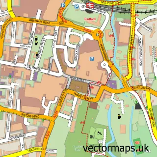
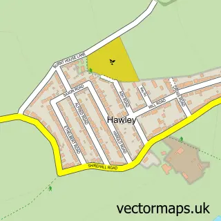
This Bowmans street map is a detailed vector street map covering a 750m x 750m area. Select a larger area to create and download your own vector street map of Bowmans.
The 750-metre map sample for Bowmans covers 322 mapped buildings and approximately 14.1 km of road detail, of which 25 named roads are named. The immediate area includes 10 GP surgeries within 2 miles, 1 pub and 25 MOT stations within 2 miles. The wider area around Bowmans features 1 tourism point of interest and 1 food and drink venue. To create a larger or custom map of Bowmans, the map builder lets you define your own coverage area and download editable SVG, PDF and PNG files.
Create a larger editable map of Bowmans
Choose any area you need and generate a high-quality vector map instantly. Perfect for print, planning, design, business and personal use.

This Bowmans street map in Kent is available as downloadable SVG, PDF and PNG map files, or as a printed map for planning, business, display, education, local information and design work. You can also create a larger custom map area using the map selector.
What this Bowmans map sample shows
Bowmans lies within Greater London Authority parish, part of Crayford ward in the Bexley London Boro local authority area. The postcode geography for this area includes the DA postcode area, the DA1 postcode district and the DA1 4 postcode sector. Residents fall under the Nhs South East London Integrated Care Board for NHS services.
Local features near Bowmans
Within 2 milesAmenities and services in and around Bowmans.
Administrative and postcode information for Bowmans
Bowmans lies within Greater London Authority parish, part of Crayford ward in the Bexley London Boro local authority area. The postcode geography for this area includes the DA postcode area, the DA1 postcode district and the DA1 4 postcode sector. Residents fall under the Nhs South East London Integrated Care Board for NHS services.
Nearby street map samples around Bowmans


More street maps in Kent
750 metre map area coverage
Boundary, postcode and point of interest information for the 750m x 750m rectangle centred on this sample map.
Boundaries containing map centre
Constituency: Dartford Co Const
County: Kent County
District: Dartford District (B)
Icb: NHS Kent and Medway ICB
Postcode District: DA1
Postcode Sector: DA1 3
Ward: Heath Ward
Nearby boundaries intersecting sample
Constituency: Bexleyheath and Crayford Boro Const
County: Greater London Authority
District: Bexley London Boro
Icb: NHS South East London ICB
Police Force: kent, metropolitan
Ward: Crayford Ward
Postcode coverage
POI category counts
Building Supply Store: 3
Alternative Medicine: 1
Arts And Entertainment: 1
Bakery: 1
Engineering Services: 1
Gardener: 1
Janitorial Services: 1
Landmark And Historical Building: 1
Naturopathic Holistic: 1
Pub: 1
Sample points of interest
- Heathside Centre For Health & Healing
- Professional Make Up by Sarah
- Victoria's Cake Stand
- Clive Scott Chimney Sweeps
- Pratts Timber & Builders Merchants
- Traditional Roofing Specialist
- FM Conway
- Stonerite
- A-Team Pest Control
- Wansunt Pit
- Heathside Health with Julie Q
- Pub Pooley
Create a larger editable map of Bowmans
This sample shows only a 750 metre area. To create a larger map of Bowmans, use our map builder to choose your own coverage area, add titles and download editable SVG, PDF and PNG files.
Create a custom map of Bowmans