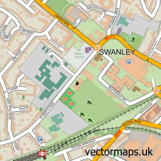
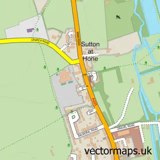
This Swanley Village street map is a detailed vector street map covering a 750m x 750m area. Select a larger area to create and download your own vector street map of Swanley Village.
The 750-metre map sample for Swanley Village covers 148 mapped buildings and approximately 8.3 km of road detail, of which 7 named roads are named. The immediate area includes 1 school, 1 GP surgery within 2 miles, 1 pub and 8 MOT stations within 2 miles. The wider area around Swanley Village features 1 food and drink venue. To create a larger or custom map of Swanley Village, the map builder lets you define your own coverage area and download editable SVG, PDF and PNG files.
Create a larger editable map of Swanley Village
Choose any area you need and generate a high-quality vector map instantly. Perfect for print, planning, design, business and personal use.

This Swanley Village street map in Kent is available as downloadable SVG, PDF and PNG map files, or as a printed map for planning, business, display, education, local information and design work. You can also create a larger custom map area using the map selector.
What this Swanley Village map sample shows
Swanley Village lies within Hextable Cp parish, part of Hextable ward in the Sevenoaks District local authority area. The postcode geography for this area includes the BR postcode area, the BR8 postcode district and the BR8 7 postcode sector. Residents fall under the Nhs Kent And Medway Integrated Care Board for NHS services.
Local features near Swanley Village
Within 2 milesAmenities and services in and around Swanley Village.
Administrative and postcode information for Swanley Village
The local authority covering Swanley Village is Sevenoaks District, within the county of Kent. The settlement lies within Hextable ward and Hextable Cp civil parish. The BR8 postcode district and BR8 7 postcode sector serve the immediate area. NHS provision in the area is delivered through Dartford And Gravesham Nhs Trust.
Nearby street map samples around Swanley Village


More street maps in Kent
750 metre map area coverage
Boundary, postcode and point of interest information for the 750m x 750m rectangle centred on this sample map.
Boundaries containing map centre
Constituency: Sevenoaks Co Const
County: Kent County
District: Sevenoaks District
Icb: NHS Kent and Medway ICB
Parish: Swanley CP
Police Force: kent
Postcode District: BR8
Postcode Sector: BR8 7
Ward: Swanley Christchurch and Swanley Village Ward
Nearby boundaries intersecting sample
Postcode Sector: BR8 8
Ward: Swanley White Oak Ward
Postcode coverage
POI category counts
Lawn Service: 2
Anglican Church: 1
Beauty And Spa: 1
Cinema: 1
Elementary School: 1
Event Technology Service: 1
Irish Pub: 1
Metal Supplier: 1
Movie Television Studio: 1
Professional Services: 1
Sample points of interest
- St Paul's, Swanley Village
- Steph Wisdom Hair Studio
- Swanley Village
- St Pauls C of E Primary School
- Meadow Fields Marquees
- Lamb Inn
- LawnsOne Ltd. - Professional Lawns, Professional People
- Lawnsone
- Artscroll Security
- Magnavision TV
- James & J Consultancy Services
- The Red Lion
Create a larger editable map of Swanley Village
This sample shows only a 750 metre area. To create a larger map of Swanley Village, use our map builder to choose your own coverage area, add titles and download editable SVG, PDF and PNG files.
Create a custom map of Swanley Village