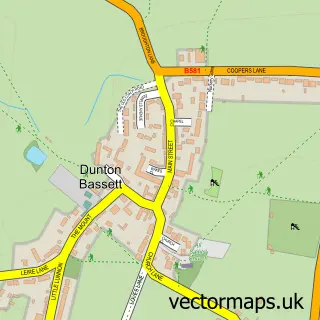
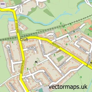
This Broughton Astley street map is a detailed vector street map covering a 750m x 750m area. Select a larger area to create and download your own vector street map of Broughton Astley.
The 750-metre map sample for Broughton Astley covers 469 mapped buildings and approximately 38.3 km of road detail, of which 37 named roads are named. The immediate area includes 1 primary school and 1 secondary school, 1 GP surgery within 2 miles, 2 pubs and 5 MOT stations within 2 miles. The wider area around Broughton Astley features 2 food and drink venues. To create a larger or custom map of Broughton Astley, the map builder lets you define your own coverage area and download editable SVG, PDF and PNG files.
Create a larger editable map of Broughton Astley
Choose any area you need and generate a high-quality vector map instantly. Perfect for print, planning, design, business and personal use.

This Broughton Astley street map in Leicestershire is available as downloadable SVG, PDF and PNG map files, or as a printed map for planning, business, display, education, local information and design work. You can also create a larger custom map area using the map selector.
What this Broughton Astley map sample shows
Broughton Astley lies within Broughton Astley Cp parish, part of Broughton Astley-Primethorpe & Sutton ward in the Harborough District local authority area. The postcode geography for this area includes the LE postcode area, the LE9 postcode district and the LE9 6 postcode sector. Residents fall under the Nhs Leicester, Leicestershire And Rutland Integrated Care Board for NHS services.
Local features near Broughton Astley
Within 2 milesAmenities and services in and around Broughton Astley.
Administrative and postcode information for Broughton Astley
The local authority covering Broughton Astley is Harborough District, within the county of Leicestershire. The settlement lies within Broughton Astley-Primethorpe & Sutton ward and Broughton Astley Cp civil parish. The LE9 postcode district and LE9 6 postcode sector serve the immediate area. NHS provision in the area is delivered through University Hospitals Of Leicester Nhs Trust.
Nearby street map samples around Broughton Astley


More street maps in Leicestershire
750 metre map area coverage
Boundary, postcode and point of interest information for the 750m x 750m rectangle centred on this sample map.
Boundaries containing map centre
Constituency: South Leicestershire Co Const
County: Leicestershire County
District: Harborough District
Icb: NHS Leicester Leicestershire and Rutland ICB
Parish: Broughton Astley CP
Police Force: leicestershire
Postcode District: LE9
Postcode Sector: LE9 6
Ward: Broughton Astley-Primethorpe & Sutton Ward
Nearby boundaries intersecting sample
Ward: Broughton Astley South & Leire Ward
Postcode coverage
POI category counts
Building Supply Store: 5
Freight And Cargo Service: 3
Wholesale Store: 3
Advertising Agency: 2
Community Services Non Profits: 2
Elementary School: 2
Engineering Services: 2
Event Technology Service: 2
Hot Tubs And Pools: 2
Physical Therapy: 2
Sample points of interest
- Axiom Design Resource
- Balloons Galore
- db automation
- LynchPin car&commercial repairs Ltd
- Multicell International Ltd.
- Beauty Treats
- Beauty by Jenny
- A C Services UK
- Alan Davies Preservations
- Narborough Electrical Contracures
- UK Flooring Supplies Online
- Westcotes Flooring Co
Create a larger editable map of Broughton Astley
This sample shows only a 750 metre area. To create a larger map of Broughton Astley, use our map builder to choose your own coverage area, add titles and download editable SVG, PDF and PNG files.
Create a custom map of Broughton Astley