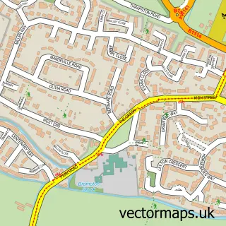
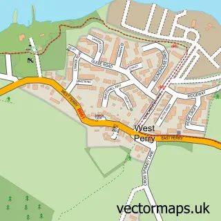
This Buckden street map is a detailed vector street map covering a 750m x 750m area. Select a larger area to create and download your own vector street map of Buckden.
The 750-metre map sample for Buckden covers 415 mapped buildings and approximately 16.9 km of road detail, of which 28 named roads are named. The immediate area includes 1 school, 1 GP surgery, 1 pub and 2 MOT stations within 2 miles. The wider area around Buckden features 2 tourism points of interest, 1 food and drink venue and 3 hotels. To create a larger or custom map of Buckden, the map builder lets you define your own coverage area and download editable SVG, PDF and PNG files.
Create a larger editable map of Buckden
Choose any area you need and generate a high-quality vector map instantly. Perfect for print, planning, design, business and personal use.

This Buckden street map in Cambridgeshire is available as downloadable SVG, PDF and PNG map files, or as a printed map for planning, business, display, education, local information and design work. You can also create a larger custom map area using the map selector.
What this Buckden map sample shows
Buckden lies within Buckden Cp parish, part of Buckden ward in the Huntingdonshire District local authority area. The postcode geography for this area includes the PE postcode area, the PE19 postcode district and the PE19 5 postcode sector. Residents fall under the Nhs Cambridgeshire And Peterborough Integrated Care Board for NHS services.
Local features near Buckden
Within 2 milesAmenities and services in and around Buckden.
Administrative and postcode information for Buckden
Buckden lies within Buckden Cp parish, part of Buckden ward in the Huntingdonshire District local authority area. The postcode geography for this area includes the PE postcode area, the PE19 postcode district and the PE19 5 postcode sector. Residents fall under the Nhs Cambridgeshire And Peterborough Integrated Care Board for NHS services.
Nearby street map samples around Buckden

More street maps in Cambridgeshire
750 metre map area coverage
Boundary, postcode and point of interest information for the 750m x 750m rectangle centred on this sample map.
Boundaries containing map centre
Constituency: Huntingdon Co Const
County: Cambridgeshire County
District: Huntingdonshire District
Icb: NHS Central East ICB
Parish: Buckden CP
Police Force: cambridgeshire
Postcode District: PE19
Postcode Sector: PE19 5
Ward: Buckden Ward
Nearby boundaries intersecting sample
No additional intersecting boundaries found.
Postcode coverage
POI category counts
Convenience Store: 4
Dentist: 3
Hotel: 3
Beauty Salon: 2
Building Supply Store: 2
Business Management Services: 2
Elementary School: 2
Landmark And Historical Building: 2
Post Office: 2
Sand And Gravel Supplier: 2
Sample points of interest
- Buckden Towers
- St Mary's Buckden
- Thechesspiece
- The Beauty Room
- The Salon On The Green
- Cambridge Pest Services
- ProLawnCare
- Jacque Louize Virtual Assistant
- Meditation In The Workplace
- St Hugh of Lincoln RC Church
- Friends of Buckden Towers
- Sunflower House
Create a larger editable map of Buckden
This sample shows only a 750 metre area. To create a larger map of Buckden, use our map builder to choose your own coverage area, add titles and download editable SVG, PDF and PNG files.
Create a custom map of Buckden