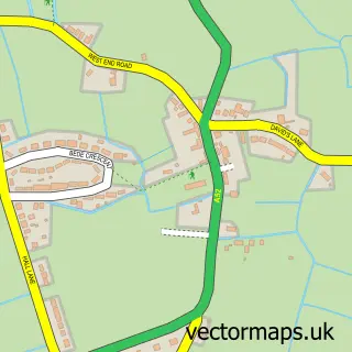
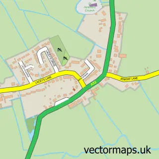
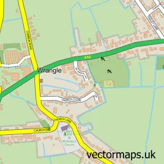
This Butterwick street map is a detailed vector street map covering a 750m x 750m area. Select a larger area to create and download your own vector street map of Butterwick.
The 750-metre map sample for Butterwick covers 359 mapped buildings and approximately 10.0 km of road detail, of which 14 named roads are named. The immediate area includes 1 pub and 1 MOT station, with 4 within 2 miles. The wider area around Butterwick features 1 food and drink venue. To create a larger or custom map of Butterwick, the map builder lets you define your own coverage area and download editable SVG, PDF and PNG files.
Create a larger editable map of Butterwick
Choose any area you need and generate a high-quality vector map instantly. Perfect for print, planning, design, business and personal use.

This Butterwick street map in Lincolnshire is available as downloadable SVG, PDF and PNG map files, or as a printed map for planning, business, display, education, local information and design work. You can also create a larger custom map area using the map selector.
What this Butterwick map sample shows
Butterwick lies within Butterwick Cp parish, part of Coastal ward in the Boston District (B) local authority area. The postcode geography for this area includes the PE postcode area, the PE22 postcode district and the PE22 0 postcode sector. Residents fall under the Nhs Lincolnshire Integrated Care Board for NHS services.
Local features near Butterwick
Within 2 milesAmenities and services in and around Butterwick.
Administrative and postcode information for Butterwick
Butterwick lies within Butterwick Cp parish, part of Coastal ward in the Boston District (B) local authority area. The postcode geography for this area includes the PE postcode area, the PE22 postcode district and the PE22 0 postcode sector. Residents fall under the Nhs Lincolnshire Integrated Care Board for NHS services.
Nearby street map samples around Butterwick

More street maps in Lincolnshire
750 metre map area coverage
Boundary, postcode and point of interest information for the 750m x 750m rectangle centred on this sample map.
Boundaries containing map centre
Constituency: Boston and Skegness Co Const
County: Lincolnshire County
District: Boston District (B)
Icb: NHS Lincolnshire ICB
Parish: Butterwick CP
Police Force: lincolnshire
Postcode District: PE22
Postcode Sector: PE22 0
Ward: Coastal Ward
Nearby boundaries intersecting sample
Parish: Benington CP
Postcode coverage
POI category counts
Automotive Repair: 2
Convenience Store: 2
Anglican Church: 1
Arts And Entertainment: 1
Beauty Salon: 1
Building Supply Store: 1
Business Office Supplies And Stationery: 1
Car Window Tinting: 1
Church Cathedral: 1
Currency Exchange: 1
Sample points of interest
- Butterwick St Andrew
- Butterwick Village Hall
- R Lawson & Co
- Wright Autos
- The Nail Lady
- Vision Plus
- Pearsons Packages
- Vision Plus
- St Andrew's Church
- Butterwick Fryer
- Londis
- Post Office Travel Money
Create a larger editable map of Butterwick
This sample shows only a 750 metre area. To create a larger map of Butterwick, use our map builder to choose your own coverage area, add titles and download editable SVG, PDF and PNG files.
Create a custom map of Butterwick