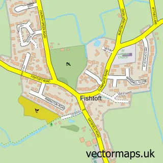
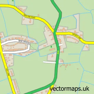
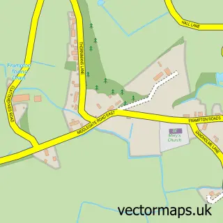
This Freiston street map is a detailed vector street map covering a 750m x 750m area. Select a larger area to create and download your own vector street map of Freiston.
The 750-metre map sample for Freiston covers 163 mapped buildings and approximately 10.6 km of road detail, of which 10 named roads are named. The immediate area includes 2 pubs and 4 MOT stations within 2 miles. The wider area around Freiston features 3 food and drink venues. To create a larger or custom map of Freiston, the map builder lets you define your own coverage area and download editable SVG, PDF and PNG files.
Create a larger editable map of Freiston
Choose any area you need and generate a high-quality vector map instantly. Perfect for print, planning, design, business and personal use.

This Freiston street map in Lincolnshire is available as downloadable SVG, PDF and PNG map files, or as a printed map for planning, business, display, education, local information and design work. You can also create a larger custom map area using the map selector.
What this Freiston map sample shows
Freiston lies within Freiston Cp parish, part of Coastal ward in the Boston District (B) local authority area. The postcode geography for this area includes the PE postcode area, the PE22 postcode district and the PE22 0 postcode sector. Residents fall under the Nhs Lincolnshire Integrated Care Board for NHS services.
Local features near Freiston
Within 2 milesAmenities and services in and around Freiston.
Administrative and postcode information for Freiston
The local authority covering Freiston is Boston District (B), within the county of Lincolnshire. The settlement lies within Coastal ward and Freiston Cp civil parish. The PE22 postcode district and PE22 0 postcode sector serve the immediate area. NHS provision in the area is delivered through United Lincolnshire Hospitals Nhs Trust.
Nearby street map samples around Freiston

More street maps in Lincolnshire
750 metre map area coverage
Boundary, postcode and point of interest information for the 750m x 750m rectangle centred on this sample map.
Boundaries containing map centre
Constituency: Boston and Skegness Co Const
County: Lincolnshire County
District: Boston District (B)
Icb: NHS Lincolnshire ICB
Parish: Freiston CP
Police Force: lincolnshire
Postcode District: PE22
Postcode Sector: PE22 0
Ward: Coastal Ward
Nearby boundaries intersecting sample
No additional intersecting boundaries found.
Postcode coverage
POI category counts
Pub: 2
Sports Club And League: 2
Anglican Church: 1
Bakery: 1
Bar: 1
Beer Bar: 1
Butcher Shop: 1
Church Cathedral: 1
Clothing Store: 1
Community Center: 1
Sample points of interest
- St James, Freiston
- Bake Me Sweet
- Kings Head Frieston
- The White Hart-Sibsey
- Watson & Stevens
- St James Churchyard
- Kwirky Kow Vintage
- Danny Flear Community Centre
- MTM Creations
- The Monks House
- Richard Pearson
- Post Office-Freiston
Create a larger editable map of Freiston
This sample shows only a 750 metre area. To create a larger map of Freiston, use our map builder to choose your own coverage area, add titles and download editable SVG, PDF and PNG files.
Create a custom map of Freiston