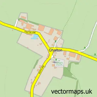
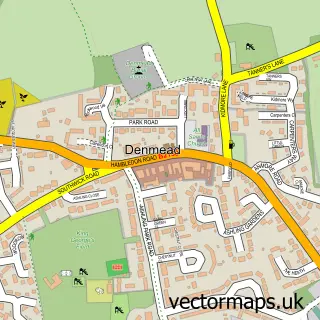
This Clanfield street map is a detailed vector street map covering a 750m x 750m area. Select a larger area to create and download your own vector street map of Clanfield.
The 750-metre map sample for Clanfield covers 202 mapped buildings and approximately 15.6 km of road detail, of which 18 named roads are named. The immediate area includes 1 school, 1 GP surgery within 2 miles, 2 pubs and 3 MOT stations within 2 miles. The wider area around Clanfield features 4 food and drink venues. To create a larger or custom map of Clanfield, the map builder lets you define your own coverage area and download editable SVG, PDF and PNG files.
Create a larger editable map of Clanfield
Choose any area you need and generate a high-quality vector map instantly. Perfect for print, planning, design, business and personal use.

This Clanfield street map in Hampshire is available as downloadable SVG, PDF and PNG map files, or as a printed map for planning, business, display, education, local information and design work. You can also create a larger custom map area using the map selector.
What this Clanfield map sample shows
Clanfield lies within Clanfield Cp parish, part of Clanfield ward in the East Hampshire District local authority area. The postcode geography for this area includes the PO postcode area, the PO8 postcode district and the PO8 0 postcode sector. Residents fall under the Nhs Hampshire And Isle Of Wight Integrated Care Board for NHS services.
Local features near Clanfield
Within 2 milesAmenities and services in and around Clanfield.
Administrative and postcode information for Clanfield
The local authority covering Clanfield is East Hampshire District, within the county of Hampshire. The settlement lies within Clanfield ward and Clanfield Cp civil parish. The PO8 postcode district and PO8 0 postcode sector serve the immediate area. NHS provision in the area is delivered through Portsmouth Hospitals University National Health Service Trust.
Nearby street map samples around Clanfield

More street maps in Hampshire
750 metre map area coverage
Boundary, postcode and point of interest information for the 750m x 750m rectangle centred on this sample map.
Boundaries containing map centre
Constituency: East Hampshire Co Const
County: Hampshire County
District: East Hampshire District
Icb: NHS Hampshire and Isle of Wight ICB
Parish: Clanfield CP
Police Force: hampshire
Postcode District: PO8
Postcode Sector: PO8 0
Ward: Clanfield Ward
Nearby boundaries intersecting sample
No additional intersecting boundaries found.
Postcode coverage
POI category counts
Beauty Salon: 3
Advertising Agency: 2
Convenience Store: 2
Gardener: 2
Hair Salon: 2
Indian Restaurant: 2
Professional Services: 2
Pub: 2
Anglican Church: 1
Appliance Manufacturer: 1
Sample points of interest
- Magellan Public Relations
- Mustard Design
- St James Church
- Clanfield Pottery
- The Planning Service
- Integrated Services (Hants) Ltd.
- Tecknowledge
- Grace medi-spa
- Flawless Guru Clinic
- Lindsey Victoria Beauty
- Lisa's Beauty Retreat
- Compass Contract Hire
Create a larger editable map of Clanfield
This sample shows only a 750 metre area. To create a larger map of Clanfield, use our map builder to choose your own coverage area, add titles and download editable SVG, PDF and PNG files.
Create a custom map of Clanfield