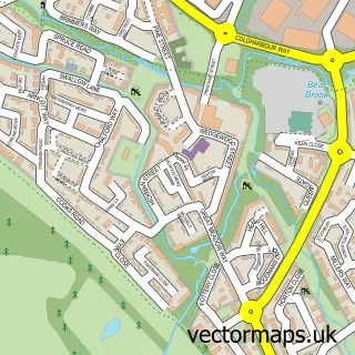
This Dinton street map is a detailed vector street map covering a 750m x 750m area. Select a larger area to create and download your own vector street map of Dinton.
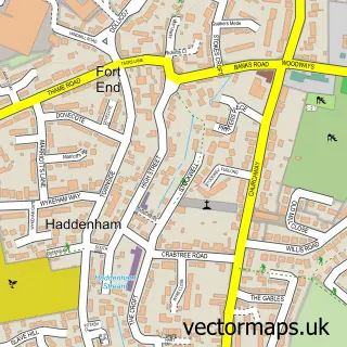
The 750-metre map sample for Dinton covers 137 mapped buildings and approximately 21.4 km of road detail, of which 11 named roads are named. The immediate area includes 1 GP surgery within 2 miles, 1 pub and 1 MOT station within 2 miles. The wider area around Dinton features 1 tourism point of interest and 1 food and drink venue. To create a larger or custom map of Dinton, the map builder lets you define your own coverage area and download editable SVG, PDF and PNG files.
Create a larger editable map of Dinton
Choose any area you need and generate a high-quality vector map instantly. Perfect for print, planning, design, business and personal use.

This Dinton street map in Buckinghamshire is available as downloadable SVG, PDF and PNG map files, or as a printed map for planning, business, display, education, local information and design work. You can also create a larger custom map area using the map selector.
What this Dinton map sample shows
Dinton lies within Dinton-With-Ford And Upton Cp parish, part of Haddenham & Stone ward in the Buckinghamshire local authority area. The postcode geography for this area includes the HP postcode area, the HP17 postcode district and the HP17 8 postcode sector. Residents fall under the Nhs Buckinghamshire, Oxfordshire And Berkshire West Integrated Care Board for NHS services.
Local features near Dinton
Within 2 milesAmenities and services in and around Dinton.
Administrative and postcode information for Dinton
The local authority covering Dinton is Buckinghamshire, within the county of Buckinghamshire. The settlement lies within Haddenham & Stone ward and Dinton-With-Ford And Upton Cp civil parish. The HP17 postcode district and HP17 8 postcode sector serve the immediate area. NHS provision in the area is delivered through Buckinghamshire Healthcare Nhs Trust.
Nearby street map samples around Dinton

More street maps in Buckinghamshire
750 metre map area coverage
Boundary, postcode and point of interest information for the 750m x 750m rectangle centred on this sample map.
Boundaries containing map centre
Constituency: Mid Buckinghamshire Co Const
District: Buckinghamshire
Icb: NHS Thames Valley ICB
Parish: Dinton-with-Ford and Upton CP
Police Force: thames valley
Postcode District: HP17
Postcode Sector: HP17 8
Ward: Haddenham & Stone Ward
Nearby boundaries intersecting sample
Postcode District: HP18
Postcode Sector: HP18 0
Postcode coverage
POI category counts
Church Cathedral: 3
Agricultural Cooperatives: 1
Anglican Church: 1
Belgian Restaurant: 1
Building Supply Store: 1
Bus Service: 1
Cricket Ground: 1
Elementary School: 1
Landmark And Historical Building: 1
Pet Boarding: 1
Sample points of interest
- Dinton Farm
- SS Peter and Paul
- La Chouette
- Liberty Livestock Systems
- Red Rose Travel Buses
- Biserica Ortodoxa Aylesbury - Sf. Femei Mironosite | Orthodox Church - The Myrrh-Bearing Women Parish
- Dinton Church
- St Peter and St Paul's Church
- Dinton Cricket Club
- Cuddington and Dinton Church of England Primary School
- Westlington
- Dinton Dog Walker
Create a larger editable map of Dinton
This sample shows only a 750 metre area. To create a larger map of Dinton, use our map builder to choose your own coverage area, add titles and download editable SVG, PDF and PNG files.
Create a custom map of Dinton