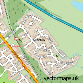
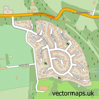
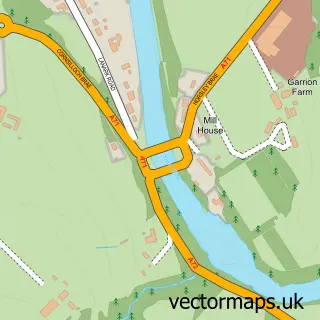
This Ferniegair street map is a detailed vector street map covering a 750m x 750m area. Select a larger area to create and download your own vector street map of Ferniegair.
The 750-metre map sample for Ferniegair covers 243 mapped buildings and approximately 13.8 km of road detail, of which 19 named roads are named. The immediate area includes 1 railway station, 10 GP surgeries within 2 miles, 1 pub and 17 MOT stations within 2 miles. The wider area around Ferniegair features 1 food and drink venue and 1 hotel. To create a larger or custom map of Ferniegair, the map builder lets you define your own coverage area and download editable SVG, PDF and PNG files.
Create a larger editable map of Ferniegair
Choose any area you need and generate a high-quality vector map instantly. Perfect for print, planning, design, business and personal use.

This Ferniegair street map in Lanarkshire is available as downloadable SVG, PDF and PNG map files, or as a printed map for planning, business, display, education, local information and design work. You can also create a larger custom map area using the map selector.
What this Ferniegair map sample shows
Ferniegair lies within South Lanarkshire parish, part of Hamilton North And East ward in the South Lanarkshire local authority area. The postcode geography for this area includes the ML postcode area, the ML3 postcode district and the ML3 7 postcode sector. Residents fall under the Lanarkshire for NHS services.
Local features near Ferniegair
Within 2 milesAmenities and services in and around Ferniegair.
Administrative and postcode information for Ferniegair
Ferniegair lies within South Lanarkshire parish, part of Hamilton North And East ward in the South Lanarkshire local authority area. The postcode geography for this area includes the ML postcode area, the ML3 postcode district and the ML3 7 postcode sector. Residents fall under the Lanarkshire for NHS services.
Nearby street map samples around Ferniegair

More street maps in Lanarkshire
750 metre map area coverage
Boundary, postcode and point of interest information for the 750m x 750m rectangle centred on this sample map.
Boundaries containing map centre
Constituency: Hamilton and Clyde Valley Co Const
District: South Lanarkshire
Icb: Lanarkshire
Postcode District: ML3
Postcode Sector: ML3 7
Ward: Hamilton North and East Ward
Nearby boundaries intersecting sample
No additional intersecting boundaries found.
Postcode coverage
POI category counts
Train Station: 2
Church Cathedral: 1
Community Center: 1
Elementary School: 1
Flowers And Gifts Shop: 1
Home Health Care: 1
Hotel: 1
Pub: 1
Used Car Dealer: 1
Sample points of interest
- Ferniegair Christian Spiritualist Church
- Ferniegair Hall
- Debutots Early Years Drama
- Oscar's Designs
- Carewatch
- Coral Bay Beach Hotel Resort
- Chatelherault Inn
- Chatelherault
- Chatelherault railway station
- Colin Park
Create a larger editable map of Ferniegair
This sample shows only a 750 metre area. To create a larger map of Ferniegair, use our map builder to choose your own coverage area, add titles and download editable SVG, PDF and PNG files.
Create a custom map of Ferniegair