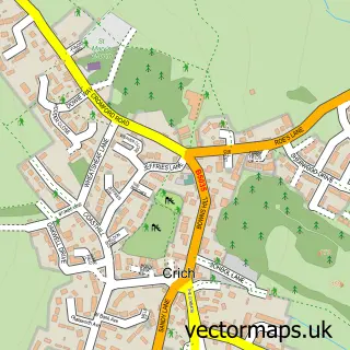
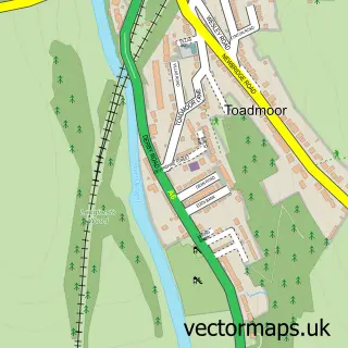
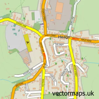
This Fritchley street map is a detailed vector street map covering a 750m x 750m area. Select a larger area to create and download your own vector street map of Fritchley.
The 750-metre map sample for Fritchley covers 194 mapped buildings and approximately 13.8 km of road detail, of which 19 named roads are named. The immediate area includes 1 school, 1 GP surgery within 2 miles, 1 pub and 2 MOT stations within 2 miles. The wider area around Fritchley features 2 tourism points of interest and 1 food and drink venue. To create a larger or custom map of Fritchley, the map builder lets you define your own coverage area and download editable SVG, PDF and PNG files.
Create a larger editable map of Fritchley
Choose any area you need and generate a high-quality vector map instantly. Perfect for print, planning, design, business and personal use.

This Fritchley street map in Derbyshire is available as downloadable SVG, PDF and PNG map files, or as a printed map for planning, business, display, education, local information and design work. You can also create a larger custom map area using the map selector.
What this Fritchley map sample shows
Fritchley lies within Crich Cp parish, part of Wingfield ward in the Amber Valley District (B) local authority area. The postcode geography for this area includes the DE postcode area, the DE56 postcode district and the DE56 2 postcode sector. Residents fall under the Nhs Derby And Derbyshire Integrated Care Board for NHS services.
Local features near Fritchley
Within 2 milesAmenities and services in and around Fritchley.
Administrative and postcode information for Fritchley
The local authority covering Fritchley is Amber Valley District (B), within the county of Derbyshire. The settlement lies within Wingfield ward and Crich Cp civil parish. The DE56 postcode district and DE56 2 postcode sector serve the immediate area. NHS provision in the area is delivered through University Hospitals Of Derby And Burton Nhs Foundation Trust.
Nearby street map samples around Fritchley

More street maps in Derbyshire
750 metre map area coverage
Boundary, postcode and point of interest information for the 750m x 750m rectangle centred on this sample map.
Boundaries containing map centre
Constituency: Amber Valley Co Const
County: Derbyshire County
District: Amber Valley District (B)
Icb: NHS Derby and Derbyshire ICB
Parish: Crich CP
Police Force: derbyshire
Postcode District: DE56
Postcode Sector: DE56 2
Ward: Crich & South Wingfield Ward
Nearby boundaries intersecting sample
Constituency: Derbyshire Dales Co Const
Parish: Ripley CP
Postcode District: DE4
Postcode Sector: DE4 5
Ward: Heage & Ambergate Ward
Postcode coverage
POI category counts
Automotive Repair: 2
Cottage: 2
Elementary School: 2
Animal Hospital: 1
Automotive: 1
Computer Coaching: 1
Driving School: 1
Flowers And Gifts Shop: 1
Landmark And Historical Building: 1
Landscaping: 1
Sample points of interest
- Platinum Paws Professional Pet Grooming Services
- Derbyshire Diagnostics (mobile mechanic)
- SP Racing and Technical Services
- Smiths Caravan Services
- AAL Training
- Church Farm Fritchley Holiday Cottage Derbyshire
- Clematis Cottage Fritchley
- HKF School of Motoring
- Fritchley C of E Primary School
- Fritchley Church of England Primary and Nursery School
- Wild Rose Florist
- Fritchley
Create a larger editable map of Fritchley
This sample shows only a 750 metre area. To create a larger map of Fritchley, use our map builder to choose your own coverage area, add titles and download editable SVG, PDF and PNG files.
Create a custom map of Fritchley