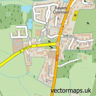
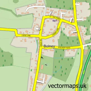
This Goddards' Green street map is a detailed vector street map covering a 750m x 750m area. Select a larger area to create and download your own vector street map of Goddards' Green.
The 750-metre map sample for Goddards' Green covers 56 mapped buildings and approximately 6.6 km of road detail, of which 4 named roads are named. The immediate area includes 2 GP surgeries within 2 miles, 1 pub and 9 MOT stations within 2 miles. The wider area around Goddards' Green features 1 tourism point of interest and 1 food and drink venue. To create a larger or custom map of Goddards' Green, the map builder lets you define your own coverage area and download editable SVG, PDF and PNG files.
Create a larger editable map of Goddards' Green
Choose any area you need and generate a high-quality vector map instantly. Perfect for print, planning, design, business and personal use.

This Goddards' Green street map in West Sussex is available as downloadable SVG, PDF and PNG map files, or as a printed map for planning, business, display, education, local information and design work. You can also create a larger custom map area using the map selector.
What this Goddards' Green map sample shows
Goddards' Green lies within Twineham Cp parish, part of Bolney ward in the Mid Sussex District local authority area. The postcode geography for this area includes the RH postcode area, the RH17 postcode district and the RH17 5 postcode sector. Residents fall under the Nhs Sussex Integrated Care Board for NHS services.
Local features near Goddards' Green
Within 2 milesAmenities and services in and around Goddards' Green.
Administrative and postcode information for Goddards' Green
The local authority covering Goddards' Green is Mid Sussex District, within the county of West Sussex. The settlement lies within Bolney ward and Twineham Cp civil parish. The RH17 postcode district and RH17 5 postcode sector serve the immediate area. NHS provision in the area is delivered through University Hospitals Sussex Nhs Foundation Trust.
Nearby street map samples around Goddards' Green


More street maps in West Sussex
750 metre map area coverage
Boundary, postcode and point of interest information for the 750m x 750m rectangle centred on this sample map.
Boundaries containing map centre
Constituency: Mid Sussex Co Const
County: West Sussex County
District: Mid Sussex District
Icb: NHS Surrey and Sussex ICB
Parish: Hurstpierpoint and Sayers Common CP
Police Force: sussex
Postcode District: BN6
Postcode Sector: BN6 9
Ward: Downland Villages Ward
Nearby boundaries intersecting sample
No additional intersecting boundaries found.
Postcode coverage
POI category counts
Building Supply Store: 3
Bed And Breakfast: 1
Convenience Store: 1
Landmark And Historical Building: 1
Pub: 1
Recycling Center: 1
Sample points of interest
- Huntsmoor Farm
- Graham the Plumbers' Merchants
- Jewson
- Jewson
- SPAR
- Goddards Green, West Sussex
- The Sportsman Pub
- British Heart Foundation
Create a larger editable map of Goddards' Green
This sample shows only a 750 metre area. To create a larger map of Goddards' Green, use our map builder to choose your own coverage area, add titles and download editable SVG, PDF and PNG files.
Create a custom map of Goddards' Green