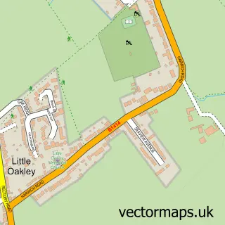
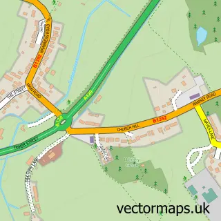
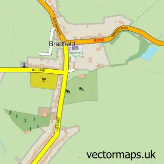
This Great Oakley street map is a detailed vector street map covering a 750m x 750m area. Select a larger area to create and download your own vector street map of Great Oakley.
The 750-metre map sample for Great Oakley covers 167 mapped buildings and approximately 7.5 km of road detail, of which 10 named roads are named. The immediate area includes 1 GP surgery, 2 pubs and 2 MOT stations within 2 miles. The wider area around Great Oakley features 2 food and drink venues. To create a larger or custom map of Great Oakley, the map builder lets you define your own coverage area and download editable SVG, PDF and PNG files.
Create a larger editable map of Great Oakley
Choose any area you need and generate a high-quality vector map instantly. Perfect for print, planning, design, business and personal use.

This Great Oakley street map in Essex is available as downloadable SVG, PDF and PNG map files, or as a printed map for planning, business, display, education, local information and design work. You can also create a larger custom map area using the map selector.
What this Great Oakley map sample shows
Great Oakley lies within Great Oakley Cp parish, part of The Oakleys & Wix ward in the Tendring District local authority area. The postcode geography for this area includes the CO postcode area, the CO12 postcode district and the CO12 5 postcode sector. Residents fall under the Nhs Suffolk And North East Essex Integrated Care Board for NHS services.
Local features near Great Oakley
Within 2 milesAmenities and services in and around Great Oakley.
Administrative and postcode information for Great Oakley
The local authority covering Great Oakley is Tendring District, within the county of Essex. The settlement lies within The Oakleys & Wix ward and Great Oakley Cp civil parish. The CO12 postcode district and CO12 5 postcode sector serve the immediate area. NHS provision in the area is delivered through East Suffolk And North Essex Nhs Foundation Trust.
Nearby street map samples around Great Oakley

More street maps in Essex
750 metre map area coverage
Boundary, postcode and point of interest information for the 750m x 750m rectangle centred on this sample map.
Boundaries containing map centre
Constituency: Clacton Co Const
County: Essex County
District: Tendring District
Icb: NHS Essex ICB
Parish: Great Oakley CP
Police Force: essex
Postcode District: CO12
Postcode Sector: CO12 5
Ward: The Oakleys & Wix Ward
Nearby boundaries intersecting sample
No additional intersecting boundaries found.
Postcode coverage
POI category counts
Doctor: 2
Pub: 2
Appliance Manufacturer: 1
Assisted Living Facility: 1
Auto Company: 1
Community Center: 1
Contractor: 1
Countertop Installation: 1
Family Practice: 1
Farm: 1
Sample points of interest
- UK Engineering Solutions
- Lime Trees Residential Home
- Clayton Motor Company
- Great Oakley Village Hall
- Drain Tech Essex
- Crockers Joinery
- Harewood Surgery
- Harewood Surgery
- Harewood Surgery
- Cullen Family Farming
- Holt Farm
- Tr Fire & Security Ltd
Create a larger editable map of Great Oakley
This sample shows only a 750 metre area. To create a larger map of Great Oakley, use our map builder to choose your own coverage area, add titles and download editable SVG, PDF and PNG files.
Create a custom map of Great Oakley