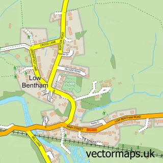
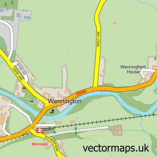
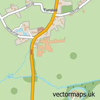
This High Bentham street map is a detailed vector street map covering a 750m x 750m area. Select a larger area to create and download your own vector street map of High Bentham.
The 750-metre map sample for High Bentham covers 334 mapped buildings and approximately 12.0 km of road detail, of which 23 named roads are named. The immediate area includes 1 railway station, 1 GP surgery, 3 pubs and 2 MOT stations. The wider area around High Bentham features 1 tourism point of interest, 8 food and drink venues and 1 hotel. To create a larger or custom map of High Bentham, the map builder lets you define your own coverage area and download editable SVG, PDF and PNG files.
Create a larger editable map of High Bentham
Choose any area you need and generate a high-quality vector map instantly. Perfect for print, planning, design, business and personal use.

This High Bentham street map in North Yorkshire is available as downloadable SVG, PDF and PNG map files, or as a printed map for planning, business, display, education, local information and design work. You can also create a larger custom map area using the map selector.
What this High Bentham map sample shows
High Bentham lies within Bentham Cp parish, part of Bentham ward in the North Yorkshire local authority area. The postcode geography for this area includes the LA postcode area, the LA2 postcode district and the LA2 7 postcode sector. Residents fall under the Nhs Lancashire And South Cumbria Integrated Care Board for NHS services.
Local features near High Bentham
Within 2 milesAmenities and services in and around High Bentham.
Administrative and postcode information for High Bentham
The local authority covering High Bentham is North Yorkshire, within the county of North Yorkshire. The settlement lies within Bentham ward and Bentham Cp civil parish. The LA2 postcode district and LA2 7 postcode sector serve the immediate area. NHS provision in the area is delivered through University Hospitals Of Morecambe Bay Nhs Foundation Trust.
Nearby street map samples around High Bentham

More street maps in North Yorkshire
750 metre map area coverage
Boundary, postcode and point of interest information for the 750m x 750m rectangle centred on this sample map.
Boundaries containing map centre
Constituency: Skipton and Ripon Co Const
District: North Yorkshire
Icb: NHS Lancashire and South Cumbria ICB
Parish: Bentham CP
Police Force: north yorkshire
Postcode District: LA2
Postcode Sector: LA2 7
Nearby boundaries intersecting sample
No additional intersecting boundaries found.
Postcode coverage
POI category counts
Professional Services: 6
Automotive Repair: 4
Beauty Salon: 4
Cafe: 4
Barber: 3
Pub: 3
Real Estate Agent: 3
Train Station: 3
Arts And Crafts: 2
Atms: 2
Sample points of interest
- Kay Dees Crafts
- Pennine Outdoor
- Bentham Town Hall
- Natwest
- The Cooperative Food High Bentham
- Bentham and District Farmers Auction Mart Co Ltd
- A I Harrison
- Fix Auto Bentham
- Grove Hill Garage
- Harrison A I and Co
- White Knight IT Solutions
- Barwise’s Bakery
Create a larger editable map of High Bentham
This sample shows only a 750 metre area. To create a larger map of High Bentham, use our map builder to choose your own coverage area, add titles and download editable SVG, PDF and PNG files.
Create a custom map of High Bentham