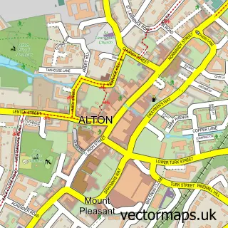
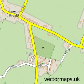
This Holybourne street map is a detailed vector street map covering a 750m x 750m area. Select a larger area to create and download your own vector street map of Holybourne.
The 750-metre map sample for Holybourne covers 289 mapped buildings and approximately 16.3 km of road detail, of which 17 named roads are named. The immediate area includes 2 schools, 1 GP surgery within 2 miles, 2 pubs and 10 MOT stations within 2 miles. The wider area around Holybourne features 2 food and drink venues. To create a larger or custom map of Holybourne, the map builder lets you define your own coverage area and download editable SVG, PDF and PNG files.
Create a larger editable map of Holybourne
Choose any area you need and generate a high-quality vector map instantly. Perfect for print, planning, design, business and personal use.

This Holybourne street map in Hampshire is available as downloadable SVG, PDF and PNG map files, or as a printed map for planning, business, display, education, local information and design work. You can also create a larger custom map area using the map selector.
What this Holybourne map sample shows
Holybourne lies within Alton Cp parish, part of Alton Holybourne ward in the East Hampshire District local authority area. The postcode geography for this area includes the GU postcode area, the GU34 postcode district and the GU34 4 postcode sector. Residents fall under the Nhs Hampshire And Isle Of Wight Integrated Care Board for NHS services.
Local features near Holybourne
Within 2 milesAmenities and services in and around Holybourne.
Administrative and postcode information for Holybourne
Holybourne lies within Alton Cp parish, part of Alton Holybourne ward in the East Hampshire District local authority area. The postcode geography for this area includes the GU postcode area, the GU34 postcode district and the GU34 4 postcode sector. Residents fall under the Nhs Hampshire And Isle Of Wight Integrated Care Board for NHS services.
Nearby street map samples around Holybourne


More street maps in Hampshire
750 metre map area coverage
Boundary, postcode and point of interest information for the 750m x 750m rectangle centred on this sample map.
Boundaries containing map centre
Constituency: East Hampshire Co Const
County: Hampshire County
District: East Hampshire District
Icb: NHS Hampshire and Isle of Wight ICB
Parish: Alton CP
Police Force: hampshire
Postcode District: GU34
Postcode Sector: GU34 4
Ward: Alton Holybourne Ward
Nearby boundaries intersecting sample
No additional intersecting boundaries found.
Postcode coverage
POI category counts
Pub: 2
Retirement Home: 2
Anglican Church: 1
Assisted Living Facility: 1
Automotive Services And Repair: 1
Car Rental Agency: 1
Church Cathedral: 1
Community Center: 1
Community Services Non Profits: 1
Counseling And Mental Health: 1
Sample points of interest
- Church of the Holy Rood, Holybourne
- Ashdale
- F X Loader
- Practical Car & Van Rental
- Holybourne Church
- Holybourne Village Hall
- Alton Camera Club
- Move Beyond Bipolar
- Post Office Travel Money
- Treloar School and College
- Andrews Endowed School
- International Academy of Saddle Fitters
Create a larger editable map of Holybourne
This sample shows only a 750 metre area. To create a larger map of Holybourne, use our map builder to choose your own coverage area, add titles and download editable SVG, PDF and PNG files.
Create a custom map of Holybourne