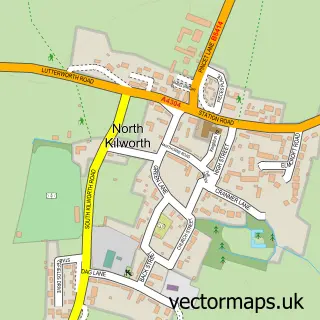
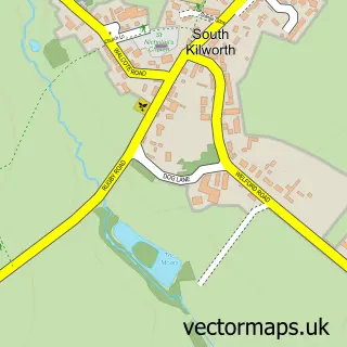
This Husbands Bosworth street map is a detailed vector street map covering a 750m x 750m area. Select a larger area to create and download your own vector street map of Husbands Bosworth.
The 750-metre map sample for Husbands Bosworth covers 240 mapped buildings and approximately 15.0 km of road detail, of which 20 named roads are named. The immediate area includes 1 school, 1 GP surgery within 2 miles, 2 pubs and 2 MOT stations within 2 miles. The wider area around Husbands Bosworth features 3 food and drink venues and 1 hotel. To create a larger or custom map of Husbands Bosworth, the map builder lets you define your own coverage area and download editable SVG, PDF and PNG files.
Create a larger editable map of Husbands Bosworth
Choose any area you need and generate a high-quality vector map instantly. Perfect for print, planning, design, business and personal use.

This Husbands Bosworth street map in Leicestershire is available as downloadable SVG, PDF and PNG map files, or as a printed map for planning, business, display, education, local information and design work. You can also create a larger custom map area using the map selector.
What this Husbands Bosworth map sample shows
Husbands Bosworth lies within Husbands Bosworth Cp parish, part of Bosworth ward in the Harborough District local authority area. The postcode geography for this area includes the LE postcode area, the LE17 postcode district and the LE17 6 postcode sector. Residents fall under the Nhs Leicester, Leicestershire And Rutland Integrated Care Board for NHS services.
Local features near Husbands Bosworth
Within 2 milesAmenities and services in and around Husbands Bosworth.
Administrative and postcode information for Husbands Bosworth
The local authority covering Husbands Bosworth is Harborough District, within the county of Leicestershire. The settlement lies within Bosworth ward and Husbands Bosworth Cp civil parish. The LE17 postcode district and LE17 6 postcode sector serve the immediate area. NHS provision in the area is delivered through University Hospitals Of Leicester Nhs Trust.
Nearby street map samples around Husbands Bosworth


More street maps in Leicestershire
750 metre map area coverage
Boundary, postcode and point of interest information for the 750m x 750m rectangle centred on this sample map.
Boundaries containing map centre
Constituency: South Leicestershire Co Const
County: Leicestershire County
District: Harborough District
Icb: NHS Leicester Leicestershire and Rutland ICB
Parish: Husbands Bosworth CP
Police Force: leicestershire
Postcode District: LE17
Postcode Sector: LE17 6
Ward: Bosworth Ward
Nearby boundaries intersecting sample
No additional intersecting boundaries found.
Postcode coverage
POI category counts
Beauty Salon: 3
Currency Exchange: 2
Elementary School: 2
Pub: 2
Retirement Home: 2
Active Life: 1
Advertising Agency: 1
Aircraft Repair: 1
Atms: 1
Auto Parts And Supply Store: 1
Sample points of interest
- Axceler-8 Hovercraft
- Toudret Design
- Hangar 25 Aviation - Aircraft maintenance & restoration
- Springfields Supermarket (Protected) (ERF Migration), HUSBANDS BOSWORTH
- D B Motors
- Hair by Lynndy
- Hair by Lynndy
- Sylvia ✄
- Stonewood Developments
- Fruit Tree Fitted Furniture
- Golden Bowl
- Sutton in the Elms Baptist Church
Create a larger editable map of Husbands Bosworth
This sample shows only a 750 metre area. To create a larger map of Husbands Bosworth, use our map builder to choose your own coverage area, add titles and download editable SVG, PDF and PNG files.
Create a custom map of Husbands Bosworth