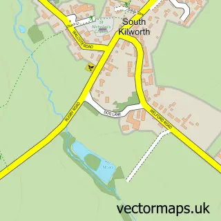
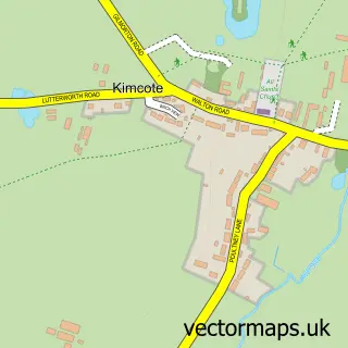
This North Kilworth street map is a detailed vector street map covering a 750m x 750m area. Select a larger area to create and download your own vector street map of North Kilworth.
The 750-metre map sample for North Kilworth covers 247 mapped buildings and approximately 21.1 km of road detail, of which 16 named roads are named. The immediate area includes 1 school, 1 GP surgery within 2 miles, 1 pub and 1 MOT station, with 2 within 2 miles. The wider area around North Kilworth features 1 tourism point of interest and 2 food and drink venues. To create a larger or custom map of North Kilworth, the map builder lets you define your own coverage area and download editable SVG, PDF and PNG files.
Create a larger editable map of North Kilworth
Choose any area you need and generate a high-quality vector map instantly. Perfect for print, planning, design, business and personal use.

This North Kilworth street map in Leicestershire is available as downloadable SVG, PDF and PNG map files, or as a printed map for planning, business, display, education, local information and design work. You can also create a larger custom map area using the map selector.
What this North Kilworth map sample shows
North Kilworth lies within North Kilworth Cp parish, part of Bosworth ward in the Harborough District local authority area. The postcode geography for this area includes the LE postcode area, the LE17 postcode district and the LE17 6 postcode sector. Residents fall under the Nhs Leicester, Leicestershire And Rutland Integrated Care Board for NHS services.
Local features near North Kilworth
Within 2 milesAmenities and services in and around North Kilworth.
Administrative and postcode information for North Kilworth
The local authority covering North Kilworth is Harborough District, within the county of Leicestershire. The settlement lies within Bosworth ward and North Kilworth Cp civil parish. The LE17 postcode district and LE17 6 postcode sector serve the immediate area. NHS provision in the area is delivered through University Hospitals Of Leicester Nhs Trust.
Nearby street map samples around North Kilworth


More street maps in Leicestershire
750 metre map area coverage
Boundary, postcode and point of interest information for the 750m x 750m rectangle centred on this sample map.
Boundaries containing map centre
Constituency: South Leicestershire Co Const
County: Leicestershire County
District: Harborough District
Icb: NHS Leicester Leicestershire and Rutland ICB
Parish: North Kilworth CP
Police Force: leicestershire
Postcode District: LE17
Postcode Sector: LE17 6
Ward: Bosworth Ward
Nearby boundaries intersecting sample
No additional intersecting boundaries found.
Postcode coverage
POI category counts
Sports Club And League: 4
Gas Station: 3
Post Office: 3
Convenience Store: 2
Elementary School: 2
Windows Installation: 2
Agriculture: 1
Anglican Church: 1
Antique Store: 1
Cafe: 1
Sample points of interest
- North Kilworth Bronzers
- St Andrew's Church, North Kilworth
- Albert's Archives Vintage and Loved
- Albert's Cafe and Tea Room
- Nenette Chocolates
- North Kilworth, St Andrew
- North Kilworth- Belgrave Village Hall
- HMS Decorative Surfacing Ltd
- Costcutter
- Nisa Local
- RP Electrical Services
- St Andrews C of E Primary School
Create a larger editable map of North Kilworth
This sample shows only a 750 metre area. To create a larger map of North Kilworth, use our map builder to choose your own coverage area, add titles and download editable SVG, PDF and PNG files.
Create a custom map of North Kilworth