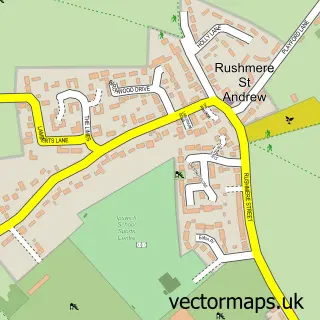
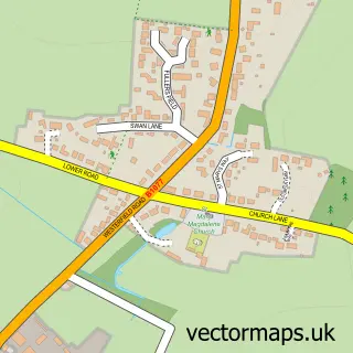
This Kesgrave street map is a detailed vector street map covering a 750m x 750m area. Select a larger area to create and download your own vector street map of Kesgrave.
The 750-metre map sample for Kesgrave covers 538 mapped buildings and approximately 18.5 km of road detail, of which 42 named roads are named. The immediate area includes 1 school, 1 GP surgery, with 3 within 2 miles, 2 pubs and 7 MOT stations within 2 miles. The wider area around Kesgrave features 2 tourism points of interest and 5 food and drink venues. To create a larger or custom map of Kesgrave, the map builder lets you define your own coverage area and download editable SVG, PDF and PNG files.
Create a larger editable map of Kesgrave
Choose any area you need and generate a high-quality vector map instantly. Perfect for print, planning, design, business and personal use.

This Kesgrave street map in Suffolk is available as downloadable SVG, PDF and PNG map files, or as a printed map for planning, business, display, education, local information and design work. You can also create a larger custom map area using the map selector.
What this Kesgrave map sample shows
Kesgrave lies within Kesgrave Cp parish, part of Kesgrave ward in the East Suffolk District local authority area. The postcode geography for this area includes the IP postcode area, the IP5 postcode district and the IP5 2 postcode sector. Residents fall under the Nhs Suffolk And North East Essex Integrated Care Board for NHS services.
Local features near Kesgrave
Within 2 milesAmenities and services in and around Kesgrave.
Administrative and postcode information for Kesgrave
The local authority covering Kesgrave is East Suffolk District, within the county of Suffolk. The settlement lies within Kesgrave ward and Kesgrave Cp civil parish. The IP5 postcode district and IP5 2 postcode sector serve the immediate area. NHS provision in the area is delivered through East Suffolk And North Essex Nhs Foundation Trust.
Nearby street map samples around Kesgrave

More street maps in Suffolk
750 metre map area coverage
Boundary, postcode and point of interest information for the 750m x 750m rectangle centred on this sample map.
Boundaries containing map centre
Constituency: Central Suffolk and North Ipswich Co Const
County: Suffolk County
District: East Suffolk District
Icb: NHS Essex ICB
Parish: Kesgrave CP
Police Force: suffolk
Postcode District: IP5
Postcode Sector: IP5 2
Ward: Kesgrave Ward
Nearby boundaries intersecting sample
Parish: Playford CP
Postcode Sector: IP5 1
Ward: Carlford & Fynn Valley Ward
Postcode coverage
POI category counts
Church Cathedral: 3
Community Services Non Profits: 3
Real Estate Agent: 3
Beauty Salon: 2
Cafe: 2
Construction Services: 2
Education: 2
Elementary School: 2
Funeral Services And Cemeteries: 2
Martial Arts Club: 2
Sample points of interest
- Rubix
- Bryden Homeopathy
- Anchor - Webbs Court
- Tesco Bank
- AA Electrical Ltd.
- Mama Bears Cake Bar
- Pro style barber
- Bellamaibeautykesgrave
- Vince&Co
- Café 66
- Fishface cafe 2024
- Carpet Cuts Ltd
Create a larger editable map of Kesgrave
This sample shows only a 750 metre area. To create a larger map of Kesgrave, use our map builder to choose your own coverage area, add titles and download editable SVG, PDF and PNG files.
Create a custom map of Kesgrave