Vector Maps logo
Home Why it works Popular maps Districts Samples Customizer Create Your Map
VectorMaps.uk
Home Popular maps Districts Samples Customizer Create Your Map Privacy Disclaimer
Home / UK Maps / Aberdeenshire / Kingseat Map

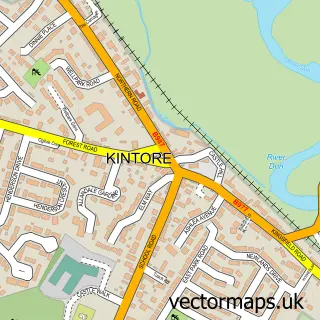
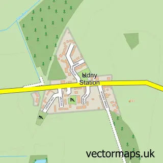
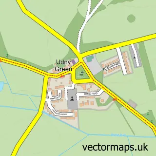
This Kingseat street map is a detailed vector street map covering a 750m x 750m area. Select a larger area to create and download your own vector street map of Kingseat.

Kingseat is a village in Aberdeenshire, in the North East Scotland of Scotland. The settlement falls within the Gordon parliamentary constituency. It is served by the AB21 postcode district, with AB21 0 as the local postcode sector.

The 750-metre map sample for Kingseat covers 241 mapped buildings and approximately 12.7 km of road detail, of which 18 named roads are named. The immediate area includes 2 MOT stations within 2 miles. To create a larger or custom map of Kingseat, the map builder lets you define your own coverage area and download editable SVG, PDF and PNG files.

241Buildings
12.74 kmRoads
18Named roads
0Residents within 2 miles
Create your own

Create a larger editable map of Kingseat

Choose any area you need and generate a high-quality vector map instantly. Perfect for print, planning, design, business and personal use.

Choose any location
Editable SVG files
Any size up to A0
PDF, PNG & more
Instant download
High quality guaranteed
Create My Custom Map
Secure, private & no credit card required
Kingseat Vector Street Map
750m Sample
Kingseat vector street map sample showing roads, buildings and local features in a 750 metre preview area
Buy Kingseat Map Print from £12.95 Buy Kingseat Digital Map from £6

This Kingseat street map in Aberdeenshire is available as downloadable SVG, PDF and PNG map files, or as a printed map for planning, business, display, education, local information and design work. You can also create a larger custom map area using the map selector.

What this Kingseat map sample shows

Kingseat lies within Aberdeenshire parish, part of Mid Formartine ward in the Aberdeenshire local authority area. The postcode geography for this area includes the AB postcode area, the AB21 postcode district and the AB21 0 postcode sector. Residents fall under the Grampian for NHS services.

Local features near Kingseat

Within 2 miles

Amenities and services in and around Kingseat.

2 MOT stations within 2 miles
3 Healthcare POIs

Counts are approximate and based on publicly available data.

Administrative and postcode information for Kingseat

Kingseat lies within Aberdeenshire parish, part of Mid Formartine ward in the Aberdeenshire local authority area. The postcode geography for this area includes the AB postcode area, the AB21 postcode district and the AB21 0 postcode sector. Residents fall under the Grampian for NHS services.

Parish ABERDEENSHIRE
Ward Mid Formartine
District / local authority Aberdeenshire
County Aberdeenshire
Historic county Aberdeenshire
Postcode district AB21
Postcode sector AB21 0
Parliamentary constituency Gordon
Region North East Scotland
Country Scotland

Nearby street map samples around Kingseat

Street map sample of Kintore, Aberdeenshire Kintore Town - Aberdeenshire - 7.1 miles Street map sample of Aberdeen, City of Aberdeen Aberdeen City - City of Aberdeen - 8.3 miles Street map sample of Newmachar, Aberdeenshire Newmachar Village - Aberdeenshire - 1.2 miles Street map sample of Belhelvie, Aberdeenshire Belhelvie Village - Aberdeenshire - 2.8 miles Street map sample of Potterton, Aberdeenshire Potterton Village - Aberdeenshire - 3.1 miles Street map sample of Udny Station, Aberdeenshire Udny Station Village - Aberdeenshire - 3.3 miles Street map sample of Balmedie, Aberdeenshire Balmedie Village - Aberdeenshire - 4.0 miles Street map sample of Hatton of Fintray, Aberdeenshire Hatton of Fintray Village - Aberdeenshire - 4.2 miles Street map sample of Blackdog, Aberdeenshire Blackdog Village - Aberdeenshire - 4.6 miles Street map sample of Udny Green, Aberdeenshire Udny Green Village - Aberdeenshire - 4.7 miles

More street maps in Aberdeenshire

Street map sample of Newmachar, Aberdeenshire Newmachar Village - 1.2 miles Street map sample of Belhelvie, Aberdeenshire Belhelvie Village - 2.8 miles Street map sample of Potterton, Aberdeenshire Potterton Village - 3.1 miles Street map sample of Udny Station, Aberdeenshire Udny Station Village - 3.3 miles Street map sample of Balmedie, Aberdeenshire Balmedie Village - 4.0 miles

750 metre map area coverage

Boundary, postcode and point of interest information for the 750m x 750m rectangle centred on this sample map.

Boundaries containing map centre

Constituency: Gordon and Buchan Co Const

District: Aberdeenshire

Icb: Grampian

Postcode District: AB21

Postcode Sector: AB21 0

Ward: East Garioch Ward

Nearby boundaries intersecting sample

Postcode Sector: AB21 7

Ward: Mid Formartine Ward

Postcode coverage

AB21 AB21 0 AB21 7

POI category counts

Dentist: 3

Beauty Salon: 2

Automobile Leasing: 1

Business: 1

Commercial Real Estate: 1

Flowers And Gifts Shop: 1

Gym: 1

Hat Shop: 1

Health And Medical: 1

Home Health Care: 1

Sample points of interest

  • VFM Scotland Limited Automobile Leasing
  • Glam Beauty Therapy Beauty Salon
  • TranQuill Nails Beauty Salon
  • Fairview Haulage Business
  • Enterprise North East Trust Commercial Real Estate
  • Bupa Dental Care Kingseat Dentist
  • Bupa Dental Care UK Dentist
  • Mint Dental Care Kingseat Dentist
  • Little Bundles Flowers And Gifts Shop
  • Body Grace Gym
  • That's The Hat Hat Shop
  • Assured Occupational Health Health And Medical

Create a larger editable map of Kingseat

This sample shows only a 750 metre area. To create a larger map of Kingseat, use our map builder to choose your own coverage area, add titles and download editable SVG, PDF and PNG files.

Create a custom map of Kingseat

Phone 01751 473136 | Copyright Vectormaps.uk 2026

Samples Customizer Privacy Disclaimer
Kingseat Vector Street Map
Kingseat enlarged street map sample showing a 750 metre preview area