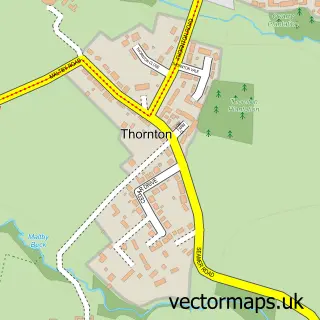
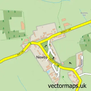
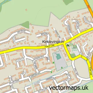
This Maltby street map is a detailed vector street map covering a 750m x 750m area. Select a larger area to create and download your own vector street map of Maltby.
The 750-metre map sample for Maltby covers 123 mapped buildings and approximately 8.4 km of road detail, of which 7 named roads are named. The immediate area includes 3 GP surgeries within 2 miles, 1 pub and 2 MOT stations within 2 miles. The wider area around Maltby features 1 food and drink venue. To create a larger or custom map of Maltby, the map builder lets you define your own coverage area and download editable SVG, PDF and PNG files.
Create a larger editable map of Maltby
Choose any area you need and generate a high-quality vector map instantly. Perfect for print, planning, design, business and personal use.

This Maltby street map in North Yorkshire is available as downloadable SVG, PDF and PNG map files, or as a printed map for planning, business, display, education, local information and design work. You can also create a larger custom map area using the map selector.
What this Maltby map sample shows
Maltby lies within Maltby Cp parish, part of Ingleby Barwick East ward in the Stockton-On-Tees (B) local authority area. The postcode geography for this area includes the TS postcode area, the TS8 postcode district and the TS8 0 postcode sector. Residents fall under the Nhs North East And North Cumbria Integrated Care Board for NHS services.
Local features near Maltby
Within 2 milesAmenities and services in and around Maltby.
Administrative and postcode information for Maltby
The local authority covering Maltby is Stockton-On-Tees (B), within the county of North Yorkshire. The settlement lies within Ingleby Barwick East ward and Maltby Cp civil parish. The TS8 postcode district and TS8 0 postcode sector serve the immediate area. NHS provision in the area is delivered through North Tees And Hartlepool Nhs Foundation Trust.
Nearby street map samples around Maltby

More street maps in North Yorkshire
750 metre map area coverage
Boundary, postcode and point of interest information for the 750m x 750m rectangle centred on this sample map.
Boundaries containing map centre
Constituency: Stockton West Co Const
District: Stockton-on-Tees (B)
Icb: NHS North East and North Cumbria ICB
Parish: Maltby CP
Police Force: cleveland
Postcode District: TS8
Postcode Sector: TS8 0
Ward: Southern Villages Ward
Nearby boundaries intersecting sample
Constituency: Middlesbrough South and East Cleveland Co Const, Middlesbrough and Thornaby East Boro Const
District: Middlesbrough (B)
Parish: Stainton and Thornton CP, Thornaby CP
Postcode District: TS17
Postcode Sector: TS17 9
Ward: Stainsby Hill Ward, Stainton & Thornton Ward
Postcode coverage
POI category counts
Accommodation: 1
Community Center: 1
Electrician: 1
Financial Advising: 1
Pub: 1
Sample points of interest
- Maltby
- Maltby Village Hall
- Electric Light and Power
- Hilton Wordsworth Financial Services
- Chadwicks Inn Maltby
Create a larger editable map of Maltby
This sample shows only a 750 metre area. To create a larger map of Maltby, use our map builder to choose your own coverage area, add titles and download editable SVG, PDF and PNG files.
Create a custom map of Maltby