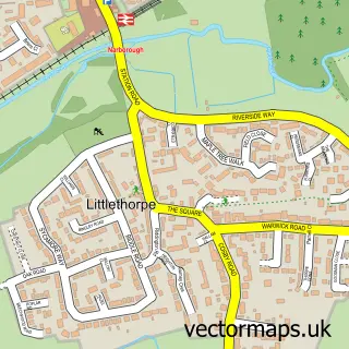
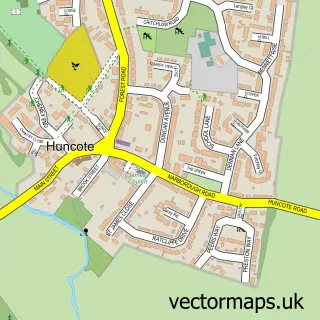
This Narborough street map is a detailed vector street map covering a 750m x 750m area. Select a larger area to create and download your own vector street map of Narborough.
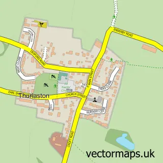
The 750-metre map sample for Narborough covers 408 mapped buildings and approximately 34.3 km of road detail, of which 44 named roads are named. The immediate area includes 1 school, 1 railway station, 4 GP surgeries within 2 miles and 1 pub among other local services. The wider area around Narborough features 1 tourism point of interest and 4 food and drink venues. To create a larger or custom map of Narborough, the map builder lets you define your own coverage area and download editable SVG, PDF and PNG files.
Create a larger editable map of Narborough
Choose any area you need and generate a high-quality vector map instantly. Perfect for print, planning, design, business and personal use.

This Narborough street map in Leicestershire is available as downloadable SVG, PDF and PNG map files, or as a printed map for planning, business, display, education, local information and design work. You can also create a larger custom map area using the map selector.
What this Narborough map sample shows
Narborough lies within Narborough Cp parish, part of Narborough And Littlethorpe ward in the Blaby District local authority area. The postcode geography for this area includes the LE postcode area, the LE19 postcode district and the LE19 3 postcode sector. Residents fall under the Nhs Leicester, Leicestershire And Rutland Integrated Care Board for NHS services.
Local features near Narborough
Within 2 milesAmenities and services in and around Narborough.
Administrative and postcode information for Narborough
Narborough lies within Narborough Cp parish, part of Narborough And Littlethorpe ward in the Blaby District local authority area. The postcode geography for this area includes the LE postcode area, the LE19 postcode district and the LE19 3 postcode sector. Residents fall under the Nhs Leicester, Leicestershire And Rutland Integrated Care Board for NHS services.
Nearby street map samples around Narborough

More street maps in Leicestershire
750 metre map area coverage
Boundary, postcode and point of interest information for the 750m x 750m rectangle centred on this sample map.
Boundaries containing map centre
Constituency: South Leicestershire Co Const
County: Leicestershire County
District: Blaby District
Icb: NHS Leicester Leicestershire and Rutland ICB
Parish: Narborough CP
Police Force: leicestershire
Postcode District: LE19
Postcode Sector: LE19 2
Ward: Narborough & Littlethorpe Ward
Nearby boundaries intersecting sample
Postcode Sector: LE19 0, LE19 3
Postcode coverage
POI category counts
Beauty Salon: 4
Driving School: 4
Barber: 3
Beauty And Spa: 3
Convenience Store: 3
Furniture Store: 3
Real Estate Agent: 3
Bakery: 2
Building Supply Store: 2
Cafe: 2
Sample points of interest
- AIMS Accountants for Business
- Narborough: All Saints, Church Lane, LE19 2GL
- Let’s Get Repaired
- Astley Building Services
- PayPoint
- Tru Motorhomes
- CA Cars Contract Hire
- Brian Bowles
- Narborough Garage
- Claire Chadd
- The bread box | Narborough
- NatWest
Create a larger editable map of Narborough
This sample shows only a 750 metre area. To create a larger map of Narborough, use our map builder to choose your own coverage area, add titles and download editable SVG, PDF and PNG files.
Create a custom map of Narborough