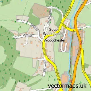
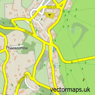
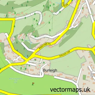
This North Woodchester street map is a detailed vector street map covering a 750m x 750m area. Select a larger area to create and download your own vector street map of North Woodchester.
The 750-metre map sample for North Woodchester covers 263 mapped buildings and approximately 41.2 km of road detail, of which 17 named roads are named. The immediate area includes 1 school, 3 GP surgeries within 2 miles, 2 pubs and 20 MOT stations within 2 miles. The wider area around North Woodchester features 2 food and drink venues. To create a larger or custom map of North Woodchester, the map builder lets you define your own coverage area and download editable SVG, PDF and PNG files.
Create a larger editable map of North Woodchester
Choose any area you need and generate a high-quality vector map instantly. Perfect for print, planning, design, business and personal use.

This North Woodchester street map in Gloucestershire is available as downloadable SVG, PDF and PNG map files, or as a printed map for planning, business, display, education, local information and design work. You can also create a larger custom map area using the map selector.
What this North Woodchester map sample shows
North Woodchester lies within Woodchester Cp parish, part of Amberley And Woodchester ward in the Stroud District local authority area. The postcode geography for this area includes the GL postcode area, the GL5 postcode district and the GL5 5 postcode sector. Residents fall under the Nhs Gloucestershire Integrated Care Board for NHS services.
Local features near North Woodchester
Within 2 milesAmenities and services in and around North Woodchester.
Administrative and postcode information for North Woodchester
The local authority covering North Woodchester is Stroud District, within the county of Gloucestershire. The settlement lies within Amberley And Woodchester ward and Woodchester Cp civil parish. The GL5 postcode district and GL5 5 postcode sector serve the immediate area. NHS provision in the area is delivered through Gloucestershire Hospitals Nhs Foundation Trust.
Nearby street map samples around North Woodchester

More street maps in Gloucestershire
750 metre map area coverage
Boundary, postcode and point of interest information for the 750m x 750m rectangle centred on this sample map.
Boundaries containing map centre
Constituency: Stroud Co Const
County: Gloucestershire County
District: Stroud District
Icb: NHS Gloucestershire ICB
Parish: Woodchester CP
Police Force: gloucestershire
Postcode District: GL5
Postcode Sector: GL5 5
Ward: Amberley and Woodchester Ward
Nearby boundaries intersecting sample
Parish: King's Stanley CP, Rodborough CP
Ward: Rodborough Ward, The Stanleys Ward
Postcode coverage
POI category counts
Building Supply Store: 3
Professional Services: 3
It Service And Computer Repair: 2
Pub: 2
Anglican Church: 1
Automotive Repair: 1
Bakery: 1
Bar: 1
Beauty Salon: 1
Business Manufacturing And Supply: 1
Sample points of interest
- St Mary Woodchester
- Gloucester Accident & Breakdown Recovery
- Halls Quality Bakers
- The Royal Oak
- Pretty Gold Soul
- The Stroud Fireplace Co
- Traditional Building Supplies
- Western Felt Roofing Stroud
- GFMicro
- Katie Crunch Handmade Confectionery
- The Parish Church of Saint Mary Woodchester
- Woodchester Priory R C Church
Create a larger editable map of North Woodchester
This sample shows only a 750 metre area. To create a larger map of North Woodchester, use our map builder to choose your own coverage area, add titles and download editable SVG, PDF and PNG files.
Create a custom map of North Woodchester