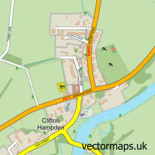
This Nuneham Courtenay street map is a detailed vector street map covering a 750m x 750m area. Select a larger area to create and download your own vector street map of Nuneham Courtenay.
The 750-metre map sample for Nuneham Courtenay covers 72 mapped buildings and approximately 6.5 km of road detail, of which 1 named road are named. The immediate area includes 1 GP surgery within 2 miles and 3 MOT stations within 2 miles. To create a larger or custom map of Nuneham Courtenay, the map builder lets you define your own coverage area and download editable SVG, PDF and PNG files.
Create a larger editable map of Nuneham Courtenay
Choose any area you need and generate a high-quality vector map instantly. Perfect for print, planning, design, business and personal use.

This Nuneham Courtenay street map in Oxfordshire is available as downloadable SVG, PDF and PNG map files, or as a printed map for planning, business, display, education, local information and design work. You can also create a larger custom map area using the map selector.
What this Nuneham Courtenay map sample shows
Nuneham Courtenay lies within Marsh Baldon Cp parish, part of Sandford & The Wittenhams ward in the South Oxfordshire District local authority area. The postcode geography for this area includes the OX postcode area, the OX44 postcode district and the OX44 9 postcode sector. Residents fall under the Nhs Buckinghamshire, Oxfordshire And Berkshire West Integrated Care Board for NHS services.
Local features near Nuneham Courtenay
Within 2 milesAmenities and services in and around Nuneham Courtenay.
Administrative and postcode information for Nuneham Courtenay
Nuneham Courtenay lies within Marsh Baldon Cp parish, part of Sandford & The Wittenhams ward in the South Oxfordshire District local authority area. The postcode geography for this area includes the OX postcode area, the OX44 postcode district and the OX44 9 postcode sector. Residents fall under the Nhs Buckinghamshire, Oxfordshire And Berkshire West Integrated Care Board for NHS services.
Nearby street map samples around Nuneham Courtenay


More street maps in Oxfordshire
750 metre map area coverage
Boundary, postcode and point of interest information for the 750m x 750m rectangle centred on this sample map.
Boundaries containing map centre
Constituency: Didcot and Wantage Co Const
County: Oxfordshire County
District: South Oxfordshire District
Icb: NHS Thames Valley ICB
Parish: Nuneham Courtenay CP
Police Force: thames valley
Postcode District: OX44
Postcode Sector: OX44 9
Ward: Sandford & the Wittenhams Ward
Nearby boundaries intersecting sample
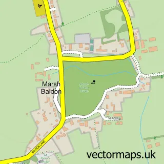
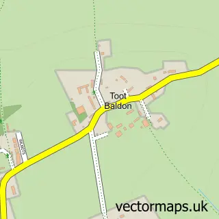
Parish: Marsh Baldon CP, Toot Baldon CP
Postcode coverage
POI category counts
Scrap Metals: 3
Business Management Services: 1
Caterer: 1
Community Services Non Profits: 1
Electrician: 1
Florist: 1
Gardener: 1
Pet Boarding: 1
Sample points of interest
- Pixel Studio
- Fallow and Fields
- Global Retreat Centre
- UK LED Lighting Direct
- Emma Walker Flowers
- Five5roses
- Cosy Cats Cattery
- Rogers Metal Management
- Rogers T R & Sons
- T R Rogers Metal Recycling
Create a larger editable map of Nuneham Courtenay
This sample shows only a 750 metre area. To create a larger map of Nuneham Courtenay, use our map builder to choose your own coverage area, add titles and download editable SVG, PDF and PNG files.
Create a custom map of Nuneham Courtenay