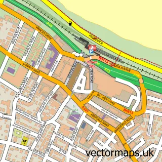
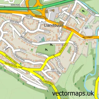
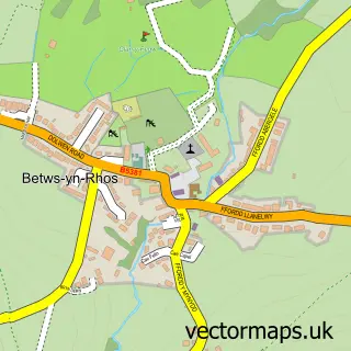
This Old Colwyn street map is a detailed vector street map covering a 750m x 750m area. Select a larger area to create and download your own vector street map of Old Colwyn.
The 750-metre map sample for Old Colwyn covers 477 mapped buildings and approximately 20.0 km of road detail, of which 45 named roads are named. The immediate area includes 2 schools, 6 pubs and 4 MOT stations within 2 miles. The wider area around Old Colwyn features 1 tourism point of interest, 15 food and drink venues and 2 hotels. To create a larger or custom map of Old Colwyn, the map builder lets you define your own coverage area and download editable SVG, PDF and PNG files.
Create a larger editable map of Old Colwyn
Choose any area you need and generate a high-quality vector map instantly. Perfect for print, planning, design, business and personal use.

This Old Colwyn street map in Clwyd is available as downloadable SVG, PDF and PNG map files, or as a printed map for planning, business, display, education, local information and design work. You can also create a larger custom map area using the map selector.
What this Old Colwyn map sample shows
Old Colwyn lies within Old Colwyn Community parish, part of Colwyn ward in the Conwy - Conwy local authority area. The postcode geography for this area includes the LL postcode area, the LL29 postcode district and the LL29 9 postcode sector. Residents fall under the Betsi Cadwaladr University Health Board for NHS services.
Local features near Old Colwyn
Within 2 milesAmenities and services in and around Old Colwyn.
Administrative and postcode information for Old Colwyn
The local authority covering Old Colwyn is Conwy - Conwy, within the county of Clwyd. The settlement lies within Colwyn ward and Old Colwyn Community civil parish. The LL29 postcode district and LL29 9 postcode sector serve the immediate area. NHS provision in the area is delivered through Betsi Cadwaladr University Health Board.
Nearby street map samples around Old Colwyn

More street maps in Clwyd
750 metre map area coverage
Boundary, postcode and point of interest information for the 750m x 750m rectangle centred on this sample map.
Boundaries containing map centre
Constituency: Clwyd North Co Const
District: Conwy - Conwy
Icb: Betsi Cadwaladr University
Parish: Old Colwyn Community
Police Force: north wales
Postcode District: LL29
Postcode Sector: LL29 9
Nearby boundaries intersecting sample
Parish: Colwyn Bay Community
Postcode Sector: LL29 8
Postcode coverage
POI category counts
Cafe: 6
Pub: 6
Beauty Salon: 5
Hair Salon: 4
Barber: 3
Beauty And Spa: 3
Building Supply Store: 3
Contractor: 3
Convenience Store: 3
Gym: 3
Sample points of interest
- Parkland Place Rehab
- St John the Baptist's Church
- Greyscale Gallery
- Asda (C) Old Colwyn - Abergele Road PFS, Abergale Road Old Colwyn
- The Cooperative Food (BF) Colwyn Bay (ERF), Old Colwyn
- The Upholstery Workshop
- Cadwgan Bakery
- Emmazing Bakes
- Barber Matt
- Thomme's Barbershop
- Zoes barbers shop
- Beautybyelliemills
Create a larger editable map of Old Colwyn
This sample shows only a 750 metre area. To create a larger map of Old Colwyn, use our map builder to choose your own coverage area, add titles and download editable SVG, PDF and PNG files.
Create a custom map of Old Colwyn