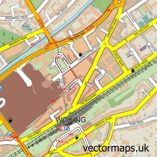
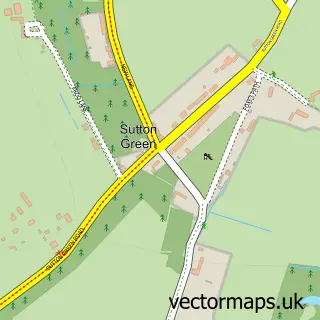
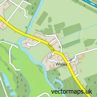
This Old Woking street map is a detailed vector street map covering a 750m x 750m area. Select a larger area to create and download your own vector street map of Old Woking.
The 750-metre map sample for Old Woking covers 470 mapped buildings and approximately 14.5 km of road detail, of which 21 named roads are named. The immediate area includes 1 school, 7 GP surgeries within 2 miles, 2 pubs and 1 MOT station, with 17 within 2 miles. The wider area around Old Woking features 2 tourism points of interest and 6 food and drink venues. To create a larger or custom map of Old Woking, the map builder lets you define your own coverage area and download editable SVG, PDF and PNG files.
Create a larger editable map of Old Woking
Choose any area you need and generate a high-quality vector map instantly. Perfect for print, planning, design, business and personal use.

This Old Woking street map in Surrey is available as downloadable SVG, PDF and PNG map files, or as a printed map for planning, business, display, education, local information and design work. You can also create a larger custom map area using the map selector.
What this Old Woking map sample shows
Old Woking lies within Surrey County parish, part of Hoe Valley ward in the Woking District (B) local authority area. The postcode geography for this area includes the GU postcode area, the GU22 postcode district and the GU22 9 postcode sector. Residents fall under the Nhs Surrey Heartlands Integrated Care Board for NHS services.
Local features near Old Woking
Within 2 milesAmenities and services in and around Old Woking.
Administrative and postcode information for Old Woking
The local authority covering Old Woking is Woking District (B), within the county of Surrey. The settlement lies within Hoe Valley ward and Surrey County civil parish. The GU22 postcode district and GU22 9 postcode sector serve the immediate area. NHS provision in the area is delivered through Ashford And St Peter's Hospitals Nhs Foundation Trust.
Nearby street map samples around Old Woking

More street maps in Surrey
750 metre map area coverage
Boundary, postcode and point of interest information for the 750m x 750m rectangle centred on this sample map.
Boundaries containing map centre
Constituency: Woking Boro Const
County: Surrey County
District: Woking District (B)
Icb: NHS Surrey and Sussex ICB
Police Force: surrey
Postcode District: GU22
Postcode Sector: GU22 9
Ward: Hoe Valley Ward
Nearby boundaries intersecting sample
Postcode Sector: GU22 8
Ward: Mount Hermon Ward
Postcode coverage
POI category counts
Professional Services: 4
Advertising Agency: 3
Automotive Repair: 3
Butcher Shop: 3
Industrial Equipment: 3
Plumbing: 3
Retail: 3
Audiovisual Equipment Rental: 2
Cafe: 2
Caterer: 2
Sample points of interest
- Susan Adams Acupuncture Woking
- Glassup & Stoski
- Marketing & Promotional Services
- Radius
- Rexel
- Hale End Court
- Shell Old Woking, Old Woking
- HSSToolShop.co.uk
- Hss Tool Hire
- Arthurs Bridge Garage
- Raimondi Auto Services
- Surrey Autos
Create a larger editable map of Old Woking
This sample shows only a 750 metre area. To create a larger map of Old Woking, use our map builder to choose your own coverage area, add titles and download editable SVG, PDF and PNG files.
Create a custom map of Old Woking