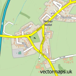
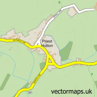
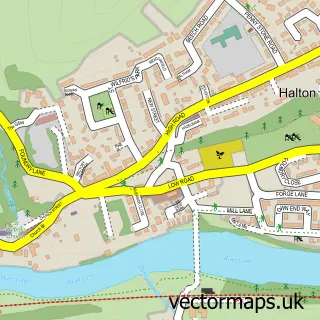
This Over Kellet street map is a detailed vector street map covering a 750m x 750m area. Select a larger area to create and download your own vector street map of Over Kellet.
The 750-metre map sample for Over Kellet covers 185 mapped buildings and approximately 10.0 km of road detail, of which 12 named roads are named. The immediate area includes 1 school, 1 GP surgery within 2 miles, 1 pub and 5 MOT stations within 2 miles. The wider area around Over Kellet features 1 tourism point of interest and 2 food and drink venues. To create a larger or custom map of Over Kellet, the map builder lets you define your own coverage area and download editable SVG, PDF and PNG files.
Create a larger editable map of Over Kellet
Choose any area you need and generate a high-quality vector map instantly. Perfect for print, planning, design, business and personal use.

This Over Kellet street map in Lancashire is available as downloadable SVG, PDF and PNG map files, or as a printed map for planning, business, display, education, local information and design work. You can also create a larger custom map area using the map selector.
What this Over Kellet map sample shows
Over Kellet lies within Over Kellet Cp parish, part of Kellet ward in the Lancaster District (B) local authority area. The postcode geography for this area includes the LA postcode area, the LA6 postcode district and the LA6 1 postcode sector. Residents fall under the Nhs Lancashire And South Cumbria Integrated Care Board for NHS services.
Local features near Over Kellet
Within 2 milesAmenities and services in and around Over Kellet.
Administrative and postcode information for Over Kellet
Over Kellet lies within Over Kellet Cp parish, part of Kellet ward in the Lancaster District (B) local authority area. The postcode geography for this area includes the LA postcode area, the LA6 postcode district and the LA6 1 postcode sector. Residents fall under the Nhs Lancashire And South Cumbria Integrated Care Board for NHS services.
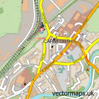
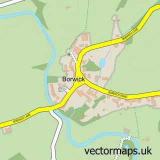
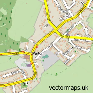
Nearby street map samples around Over Kellet

More street maps in Lancashire
750 metre map area coverage
Boundary, postcode and point of interest information for the 750m x 750m rectangle centred on this sample map.
Boundaries containing map centre
Constituency: Morecambe and Lunesdale Co Const
County: Lancashire County
District: Lancaster District (B)
Icb: NHS Lancashire and South Cumbria ICB
Parish: Over Kellet CP
Police Force: lancashire
Postcode District: LA6
Postcode Sector: LA6 1
Ward: Halton-with-Aughton & Kellet Ward
Nearby boundaries intersecting sample
No additional intersecting boundaries found.
Postcode coverage
POI category counts
Korean Grocery Store: 2
Travel Agents: 2
Architect: 1
Attractions And Activities: 1
Auto Detailing: 1
Bar: 1
Bed And Breakfast: 1
Corporate Entertainment Services: 1
Education: 1
Elementary School: 1
Sample points of interest
- Gordon Smith Architect
- LittleBig Adventures
- Morgan Valeting
- The Eagles Head
- Tithe Barn Bed and Breakfast
- Trax 2020
- Wilson's Endowed CE Primary School
- Over Kellet Wilson's Endowed Church of England Primary School
- Greenbank Farm
- Lancaster Cheese Boards
- James Hake Ceramics
- North Fork
Create a larger editable map of Over Kellet
This sample shows only a 750 metre area. To create a larger map of Over Kellet, use our map builder to choose your own coverage area, add titles and download editable SVG, PDF and PNG files.
Create a custom map of Over Kellet