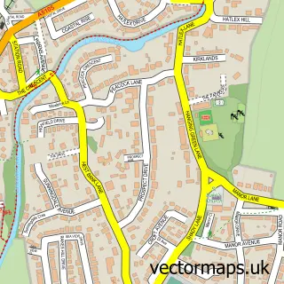
This Halton street map is a detailed vector street map covering a 750m x 750m area. Select a larger area to create and download your own vector street map of Halton.
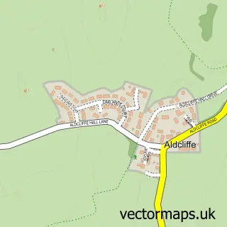
The 750-metre map sample for Halton covers 302 mapped buildings and approximately 12.0 km of road detail, of which 27 named roads are named. The immediate area includes 1 school, 2 pubs and 1 MOT station, with 4 within 2 miles. The wider area around Halton features 2 tourism points of interest and 4 food and drink venues. To create a larger or custom map of Halton, the map builder lets you define your own coverage area and download editable SVG, PDF and PNG files.
Create a larger editable map of Halton
Choose any area you need and generate a high-quality vector map instantly. Perfect for print, planning, design, business and personal use.

This Halton street map in Lancashire is available as downloadable SVG, PDF and PNG map files, or as a printed map for planning, business, display, education, local information and design work. You can also create a larger custom map area using the map selector.
What this Halton map sample shows
Halton lies within Halton-With-Aughton Cp parish, part of Halton-With-Aughton ward in the Lancaster District (B) local authority area. The postcode geography for this area includes the LA postcode area, the LA2 postcode district and the LA2 6 postcode sector. Residents fall under the Nhs Lancashire And South Cumbria Integrated Care Board for NHS services.
Local features near Halton
Within 2 milesAmenities and services in and around Halton.
Administrative and postcode information for Halton
Halton lies within Halton-With-Aughton Cp parish, part of Halton-With-Aughton ward in the Lancaster District (B) local authority area. The postcode geography for this area includes the LA postcode area, the LA2 postcode district and the LA2 6 postcode sector. Residents fall under the Nhs Lancashire And South Cumbria Integrated Care Board for NHS services.
Nearby street map samples around Halton

More street maps in Lancashire
750 metre map area coverage
Boundary, postcode and point of interest information for the 750m x 750m rectangle centred on this sample map.
Boundaries containing map centre
Constituency: Morecambe and Lunesdale Co Const
County: Lancashire County
District: Lancaster District (B)
Icb: NHS Lancashire and South Cumbria ICB
Parish: Halton-with-Aughton CP
Police Force: lancashire
Postcode District: LA2
Postcode Sector: LA2 6
Ward: Halton-with-Aughton & Kellet Ward
Nearby boundaries intersecting sample
Parish: Quernmore CP
Postcode Sector: LA2 9
Ward: Lower Lune Valley Ward
Postcode coverage
POI category counts
Cafe: 2
Community Center: 2
Elementary School: 2
Nursing School: 2
Preschool: 2
Pub: 2
Sports Club And League: 2
Accountant: 1
Acupuncture: 1
Bridge: 1
Sample points of interest
- Andrew S Parker Chartered Accountants
- Lancaster Acupuncture
- Denny Beck Bridge
- Clarkson Electrical Solutions
- Halton Village Butchers
- Bevington's Catering
- The Red Door Cafe
- St Wilfrid's Church
- The Centre
- The Centre at Halton
- AP Plastering And Building Services
- Infinity3
Create a larger editable map of Halton
This sample shows only a 750 metre area. To create a larger map of Halton, use our map builder to choose your own coverage area, add titles and download editable SVG, PDF and PNG files.
Create a custom map of Halton