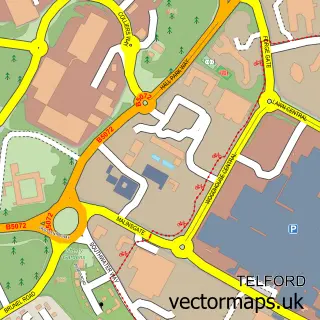
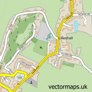
This Priorslee Village street map is a detailed vector street map covering a 750m x 750m area. Select a larger area to create and download your own vector street map of Priorslee Village.
The 750-metre map sample for Priorslee Village covers 268 mapped buildings and approximately 20.8 km of road detail, of which 21 named roads are named. The immediate area includes 2 schools, 4 GP surgeries within 2 miles, 2 pubs and 14 MOT stations within 2 miles. The wider area around Priorslee Village features 3 food and drink venues. To create a larger or custom map of Priorslee Village, the map builder lets you define your own coverage area and download editable SVG, PDF and PNG files.
Create a larger editable map of Priorslee Village
Choose any area you need and generate a high-quality vector map instantly. Perfect for print, planning, design, business and personal use.

This Priorslee Village street map in Shropshire is available as downloadable SVG, PDF and PNG map files, or as a printed map for planning, business, display, education, local information and design work. You can also create a larger custom map area using the map selector.
What this Priorslee Village map sample shows
Priorslee Village lies within Lawley And Overdale Cp parish, part of Ketley & Overdale ward in the Telford And Wrekin (B) local authority area. Residents fall under the Nhs Shropshire, Telford And Wrekin Integrated Care Board for NHS services.
Local features near Priorslee Village
Within 2 milesAmenities and services in and around Priorslee Village.
Administrative and postcode information for Priorslee Village
The local authority covering Priorslee Village is Telford And Wrekin (B), within the county of Shropshire. The settlement lies within Ketley & Overdale ward and Lawley And Overdale Cp civil parish. NHS provision in the area is delivered through The Shrewsbury And Telford Hospital Nhs Trust.
Nearby street map samples around Priorslee Village

More street maps in Shropshire
750 metre map area coverage
Boundary, postcode and point of interest information for the 750m x 750m rectangle centred on this sample map.
Boundaries containing map centre
Constituency: Telford Boro Const
District: Telford and Wrekin (B)
Icb: NHS Shropshire Telford and Wrekin ICB
Parish: St. Georges and Priorslee CP
Police Force: west mercia
Postcode District: TF2
Postcode Sector: TF2 9
Ward: Priorslee Ward
Nearby boundaries intersecting sample
Parish: Hollinswood and Randlay CP, Lawley and Overdale CP, Oakengates CP
Postcode District: TF3
Postcode Sector: TF3 3
Ward: Malinslee & Dawley Bank Ward, Oakengates & Ketley Bank Ward, The Nedge Ward
Postcode coverage
POI category counts
Professional Services: 7
Education: 5
Automotive Services And Repair: 4
Software Development: 4
Architectural Designer: 3
Gym: 3
It Service And Computer Repair: 3
Web Designer: 3
Advertising Agency: 2
Antenna Service: 2
Sample points of interest
- Telford STaRS
- kinlet Hall
- The Design Frontier
- Time Marque International
- Watts TV www.wattstvdigitaltelford.co.uk
- Watts Tv
- 4Ward Architects
- A P Architecture Ltd
- ASG Architects Ltd
- The Cooperative Food (BF) Priorslee (ERF), Priorslee Avenue
- National Platforms
- HPS
Create a larger editable map of Priorslee Village
This sample shows only a 750 metre area. To create a larger map of Priorslee Village, use our map builder to choose your own coverage area, add titles and download editable SVG, PDF and PNG files.
Create a custom map of Priorslee Village