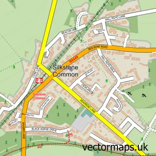
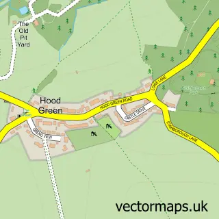
This Silkstone street map is a detailed vector street map covering a 750m x 750m area. Select a larger area to create and download your own vector street map of Silkstone.
The 750-metre map sample for Silkstone covers 431 mapped buildings and approximately 12.8 km of road detail, of which 28 named roads are named. The immediate area includes 1 school, 2 pubs and 2 MOT stations within 2 miles. The wider area around Silkstone features 1 tourism point of interest and 4 food and drink venues. To create a larger or custom map of Silkstone, the map builder lets you define your own coverage area and download editable SVG, PDF and PNG files.
Create a larger editable map of Silkstone
Choose any area you need and generate a high-quality vector map instantly. Perfect for print, planning, design, business and personal use.

This Silkstone street map in South Yorkshire is available as downloadable SVG, PDF and PNG map files, or as a printed map for planning, business, display, education, local information and design work. You can also create a larger custom map area using the map selector.
What this Silkstone map sample shows
Silkstone lies within Silkstone Cp parish, part of Penistone East ward in the Barnsley District (B) local authority area. The postcode geography for this area includes the S postcode area, the S75 postcode district and the S75 4 postcode sector. Residents fall under the Nhs South Yorkshire Integrated Care Board for NHS services.
Local features near Silkstone
Within 2 milesAmenities and services in and around Silkstone.
Administrative and postcode information for Silkstone
The local authority covering Silkstone is Barnsley District (B), within the county of South Yorkshire. The settlement lies within Penistone East ward and Silkstone Cp civil parish. The S75 postcode district and S75 4 postcode sector serve the immediate area. NHS provision in the area is delivered through Barnsley Hospital Nhs Foundation Trust.
Nearby street map samples around Silkstone

More street maps in South Yorkshire
750 metre map area coverage
Boundary, postcode and point of interest information for the 750m x 750m rectangle centred on this sample map.
Boundaries containing map centre
Constituency: Penistone and Stocksbridge Co Const
District: Barnsley District (B)
Icb: NHS South Yorkshire ICB
Parish: Silkstone CP
Police Force: south yorkshire
Postcode District: S75
Postcode Sector: S75 4
Ward: Penistone East Ward
Nearby boundaries intersecting sample
No additional intersecting boundaries found.
Postcode coverage
POI category counts
Beauty Salon: 3
Childrens Clothing Store: 3
Doctor: 2
Education: 2
Pet Services: 2
Pub: 2
Anglican Church: 1
Bridal Shop: 1
Business Consulting: 1
Church Cathedral: 1
Sample points of interest
- Silkstone, All Saints
- Body Revive
- Hollie Mitchell Hair Design
- The Old Glass Works Hair Salon
- Jules Brides
- Project Management Software Centre
- Barnsley Toddler Sense
- Jess & The Tribe
- Pookie Womenswear
- All Saints Church
- The Potting Shed Cafe
- Penistone Group Practice - Silkstone Branch
Create a larger editable map of Silkstone
This sample shows only a 750 metre area. To create a larger map of Silkstone, use our map builder to choose your own coverage area, add titles and download editable SVG, PDF and PNG files.
Create a custom map of Silkstone