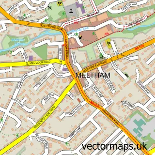
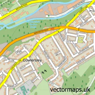
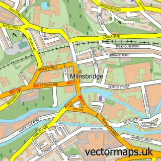
This Slaithwaite street map is a detailed vector street map covering a 750m x 750m area. Select a larger area to create and download your own vector street map of Slaithwaite.
The 750-metre map sample for Slaithwaite covers 317 mapped buildings and approximately 24.0 km of road detail, of which 59 named roads are named. The immediate area includes 1 railway station, 2 GP surgeries, with 3 within 2 miles, 8 pubs and 2 MOT stations, with 5 within 2 miles. The wider area around Slaithwaite features 2 tourism points of interest, 19 food and drink venues and 1 hotel. To create a larger or custom map of Slaithwaite, the map builder lets you define your own coverage area and download editable SVG, PDF and PNG files.
Create a larger editable map of Slaithwaite
Choose any area you need and generate a high-quality vector map instantly. Perfect for print, planning, design, business and personal use.

This Slaithwaite street map in West Yorkshire is available as downloadable SVG, PDF and PNG map files, or as a printed map for planning, business, display, education, local information and design work. You can also create a larger custom map area using the map selector.
What this Slaithwaite map sample shows
Slaithwaite lies within Kirklees District (B) parish, part of Colne Valley ward in the Kirklees District (B) local authority area. The postcode geography for this area includes the HD postcode area, the HD7 postcode district and the HD7 5 postcode sector. Residents fall under the Nhs West Yorkshire Integrated Care Board for NHS services.
Local features near Slaithwaite
Within 2 milesAmenities and services in and around Slaithwaite.
Administrative and postcode information for Slaithwaite
Slaithwaite lies within Kirklees District (B) parish, part of Colne Valley ward in the Kirklees District (B) local authority area. The postcode geography for this area includes the HD postcode area, the HD7 postcode district and the HD7 5 postcode sector. Residents fall under the Nhs West Yorkshire Integrated Care Board for NHS services.
Nearby street map samples around Slaithwaite

More street maps in West Yorkshire
750 metre map area coverage
Boundary, postcode and point of interest information for the 750m x 750m rectangle centred on this sample map.
Boundaries containing map centre
Constituency: Colne Valley Co Const
District: Kirklees District (B)
Icb: NHS West Yorkshire ICB
Police Force: west yorkshire
Postcode District: HD7
Postcode Sector: HD7 5
Ward: Colne Valley Ward
Nearby boundaries intersecting sample
No additional intersecting boundaries found.
Postcode coverage
POI category counts
Cafe: 9
Pub: 8
Convenience Store: 5
Flowers And Gifts Shop: 5
Professional Services: 5
Bakery: 4
Building Supply Store: 4
Advertising Agency: 3
Beauty And Spa: 3
Beauty Salon: 3
Sample points of interest
- Points Clinic
- Points Fertility Acupuncture
- Learn To Plaster Ltd.
- Date of Birth Creative Design & Marketing
- Maxwell Marketing
- Para Creative
- Pennine Farm Services
- St James
- Cobweb
- The Antiques Warehouse
- Progressive Architecture
- Xanthe Quayle Landscape Architects
Create a larger editable map of Slaithwaite
This sample shows only a 750 metre area. To create a larger map of Slaithwaite, use our map builder to choose your own coverage area, add titles and download editable SVG, PDF and PNG files.
Create a custom map of Slaithwaite