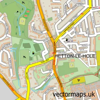
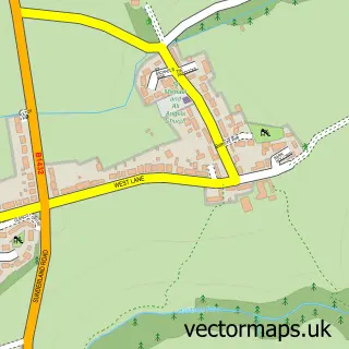
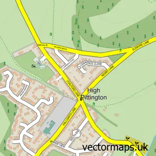
This South Hetton street map is a detailed vector street map covering a 750m x 750m area. Select a larger area to create and download your own vector street map of South Hetton.
The 750-metre map sample for South Hetton covers 309 mapped buildings and approximately 11.7 km of road detail, of which 21 named roads are named. The immediate area includes 1 school, 1 GP surgery, with 2 within 2 miles and 1 MOT station, with 7 within 2 miles. The wider area around South Hetton features 1 tourism point of interest and 2 food and drink venues. To create a larger or custom map of South Hetton, the map builder lets you define your own coverage area and download editable SVG, PDF and PNG files.
Create a larger editable map of South Hetton
Choose any area you need and generate a high-quality vector map instantly. Perfect for print, planning, design, business and personal use.

This South Hetton street map in Durham is available as downloadable SVG, PDF and PNG map files, or as a printed map for planning, business, display, education, local information and design work. You can also create a larger custom map area using the map selector.
What this South Hetton map sample shows
South Hetton lies within South Hetton Cp parish, part of Shotton And South Hetton ward in the County Durham local authority area. The postcode geography for this area includes the DH postcode area, the DH6 postcode district and the DH6 2 postcode sector. Residents fall under the Nhs North East And North Cumbria Integrated Care Board for NHS services.
Local features near South Hetton
Within 2 milesAmenities and services in and around South Hetton.
Administrative and postcode information for South Hetton
The local authority covering South Hetton is County Durham, within the county of Durham. The settlement lies within Shotton And South Hetton ward and South Hetton Cp civil parish. The DH6 postcode district and DH6 2 postcode sector serve the immediate area. NHS provision in the area is delivered through South Tyneside And Sunderland Nhs Foundation Trust.
Nearby street map samples around South Hetton

More street maps in Durham
750 metre map area coverage
Boundary, postcode and point of interest information for the 750m x 750m rectangle centred on this sample map.
Boundaries containing map centre
Constituency: Easington Co Const
District: County Durham
Icb: NHS North East and North Cumbria ICB
Parish: South Hetton CP
Police Force: durham
Postcode District: DH6
Postcode Sector: DH6 2
Nearby boundaries intersecting sample
Parish: Murton CP
Postcode District: SR7
Postcode Sector: SR7 9
Postcode coverage
POI category counts
Automotive Repair: 3
Community Center: 2
Fish And Chips Restaurant: 2
Pharmacy: 2
Restaurant: 2
Anglican Church: 1
Arts And Entertainment: 1
Assisted Living Facility: 1
Atms: 1
Auto Body Shop: 1
Sample points of interest
- Holy Trinity Church South Hetton
- Two Red Rubber Things
- Kensington Hall
- PayPoint
- North East Car Cosmetics
- AK Auto
- AK Auto
- Finch's Motor repairs Ltd
- The Academy Of Fitness Training
- S Banks Joinery
- The Parish Church Holy Trinity South Hetton
- Robin Todd Community Centre
Create a larger editable map of South Hetton
This sample shows only a 750 metre area. To create a larger map of South Hetton, use our map builder to choose your own coverage area, add titles and download editable SVG, PDF and PNG files.
Create a custom map of South Hetton