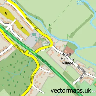
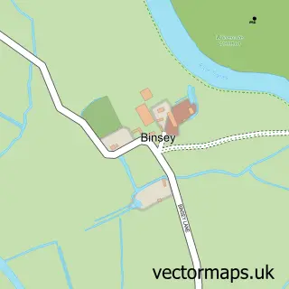
This South Hinksey street map is a detailed vector street map covering a 750m x 750m area. Select a larger area to create and download your own vector street map of South Hinksey.
The 750-metre map sample for South Hinksey covers 80 mapped buildings and approximately 16.3 km of road detail, of which 5 named roads are named. The immediate area includes 11 GP surgeries within 2 miles and 11 MOT stations within 2 miles. The wider area around South Hinksey features 1 food and drink venue and 1 campsite within 2 miles. To create a larger or custom map of South Hinksey, the map builder lets you define your own coverage area and download editable SVG, PDF and PNG files.
Create a larger editable map of South Hinksey
Choose any area you need and generate a high-quality vector map instantly. Perfect for print, planning, design, business and personal use.

This South Hinksey street map in Oxfordshire is available as downloadable SVG, PDF and PNG map files, or as a printed map for planning, business, display, education, local information and design work. You can also create a larger custom map area using the map selector.
What this South Hinksey map sample shows
South Hinksey lies within South Hinksey Cp parish, part of Botley & Sunningwell ward in the Vale Of White Horse District local authority area. The postcode geography for this area includes the OX postcode area, the OX1 postcode district and the OX1 5 postcode sector. Residents fall under the Nhs Buckinghamshire, Oxfordshire And Berkshire West Integrated Care Board for NHS services.
Local features near South Hinksey
Within 2 milesAmenities and services in and around South Hinksey.
Administrative and postcode information for South Hinksey
South Hinksey lies within South Hinksey Cp parish, part of Botley & Sunningwell ward in the Vale Of White Horse District local authority area. The postcode geography for this area includes the OX postcode area, the OX1 postcode district and the OX1 5 postcode sector. Residents fall under the Nhs Buckinghamshire, Oxfordshire And Berkshire West Integrated Care Board for NHS services.
Nearby street map samples around South Hinksey


More street maps in Oxfordshire
750 metre map area coverage
Boundary, postcode and point of interest information for the 750m x 750m rectangle centred on this sample map.
Boundaries containing map centre
Constituency: Oxford West and Abingdon Co Const
County: Oxfordshire County
District: Vale of White Horse District
Icb: NHS Thames Valley ICB
Parish: South Hinksey CP
Police Force: thames valley
Postcode District: OX1
Postcode Sector: OX1 5
Ward: Botley & Sunningwell Ward
Nearby boundaries intersecting sample
Constituency: Oxford East Boro Const
District: Oxford District (B)
Postcode Sector: OX1 4
Ward: Hinksey Park Ward
Postcode coverage
POI category counts
Anglican Church: 1
Cafe: 1
Church Cathedral: 1
Community Center: 1
Driving School: 1
Landscaping: 1
Martial Arts Club: 1
Nursery And Gardening: 1
Professional Services: 1
Sample points of interest
- St Laurence, South Hinksey
- The Garden Cafe Oxford
- St Lawrence's Church
- South Hinksey Village Hall
- Inspire Driving School
- AWBS: For all your building and landscaping supplies.
- Bushido Academy Of Martial Arts
- Oxford Garden Centre
- Promedica24 Oxford Branch
Create a larger editable map of South Hinksey
This sample shows only a 750 metre area. To create a larger map of South Hinksey, use our map builder to choose your own coverage area, add titles and download editable SVG, PDF and PNG files.
Create a custom map of South Hinksey