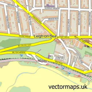
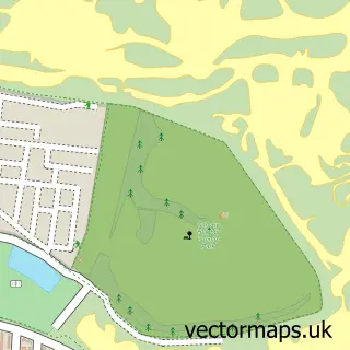
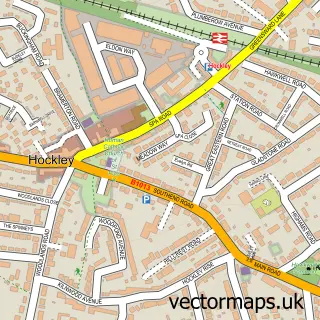
This Southend-on-Sea street map is a detailed vector street map covering a 750m x 750m area. Select a larger area to create and download your own vector street map of Southend-on-Sea.
The 750-metre map sample for Southend-on-Sea covers 199 mapped buildings and approximately 24.8 km of road detail, of which 48 named roads are named. The immediate area includes 1 school, 2 railway stations, 3 GP surgeries, with 16 within 2 miles and 10 pubs among other local services. The wider area around Southend-on-Sea features 4 tourism points of interest, 59 food and drink venues and 4 hotels. To create a larger or custom map of Southend-on-Sea, the map builder lets you define your own coverage area and download editable SVG, PDF and PNG files.
Create a larger editable map of Southend-on-Sea
Choose any area you need and generate a high-quality vector map instantly. Perfect for print, planning, design, business and personal use.

This Southend-on-Sea street map in Essex is available as downloadable SVG, PDF and PNG map files, or as a printed map for planning, business, display, education, local information and design work. You can also create a larger custom map area using the map selector.
What this Southend-on-Sea map sample shows
Southend-on-Sea lies within Southend-On-Sea (B) parish, part of Victoria ward in the Southend-On-Sea (B) local authority area. The postcode geography for this area includes the SS postcode area, the SS2 postcode district and the SS2 6 postcode sector. Residents fall under the Nhs Mid And South Essex Integrated Care Board for NHS services.
Local features near Southend-on-Sea
Within 2 milesAmenities and services in and around Southend-on-Sea.
Administrative and postcode information for Southend-on-Sea
The local authority covering Southend-on-Sea is Southend-On-Sea (B), within the county of Essex. The settlement lies within Victoria ward and Southend-On-Sea (B) civil parish. The SS2 postcode district and SS2 6 postcode sector serve the immediate area. NHS provision in the area is delivered through Mid And South Essex Nhs Foundation Trust.
Nearby street map samples around Southend-on-Sea
More street maps in Essex
750 metre map area coverage
Boundary, postcode and point of interest information for the 750m x 750m rectangle centred on this sample map.
Boundaries containing map centre
Constituency: Southend East and Rochford Co Const
District: Southend-on-Sea (B)
Icb: NHS Essex ICB
Police Force: essex
Postcode District: SS1
Postcode Sector: SS1 1
Ward: Milton Ward
Nearby boundaries intersecting sample
Postcode District: SS2
Postcode Sector: SS1 2, SS2 5, SS2 6
Ward: Kursaal Ward, Victoria Ward
Postcode coverage
POI category counts
Jewelry Store: 22
Cafe: 20
Professional Services: 17
Restaurant: 17
Fast Food Restaurant: 16
Beauty Salon: 15
Clothing Store: 15
Hair Salon: 15
Mobile Phone Store: 15
Charity Organization: 13
Sample points of interest
- Recovery First Housing
- Abraham & Associates
- Abraham and Associates
- Blenheim Accountants
- Edward Accountancy and Tax Services Ltd
- MCL Accountants Southend
- Practical Bookkeeping, Accounting and Taxation Services
- Southend Accountants
- Wilkins Kennedy Accountants
- Herbland
- Ddv Southend
- Entice Gentlemen's Club
Create a larger editable map of Southend-on-Sea
This sample shows only a 750 metre area. To create a larger map of Southend-on-Sea, use our map builder to choose your own coverage area, add titles and download editable SVG, PDF and PNG files.
Create a custom map of Southend-on-Sea