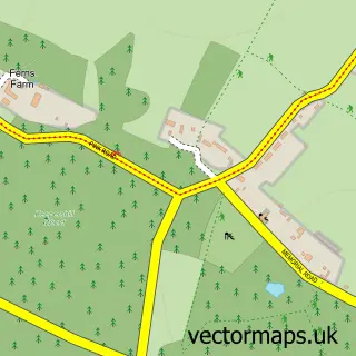
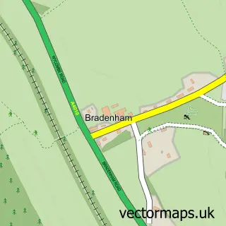
This Speen street map is a detailed vector street map covering a 750m x 750m area. Select a larger area to create and download your own vector street map of Speen.
The 750-metre map sample for Speen covers 277 mapped buildings and approximately 15.5 km of road detail, of which 19 named roads are named. The immediate area includes 1 school and 2 MOT stations within 2 miles. The wider area around Speen features 1 tourism point of interest and 1 campsite within 2 miles. To create a larger or custom map of Speen, the map builder lets you define your own coverage area and download editable SVG, PDF and PNG files.
Create a larger editable map of Speen
Choose any area you need and generate a high-quality vector map instantly. Perfect for print, planning, design, business and personal use.

This Speen street map in Buckinghamshire is available as downloadable SVG, PDF and PNG map files, or as a printed map for planning, business, display, education, local information and design work. You can also create a larger custom map area using the map selector.
What this Speen map sample shows
Speen lies within Lacey Green Cp parish, part of Lacey Green, Speen And The Hampdens ward in the Buckinghamshire local authority area. The postcode geography for this area includes the HP postcode area, the HP27 postcode district and the HP27 0 postcode sector. Residents fall under the Nhs Buckinghamshire, Oxfordshire And Berkshire West Integrated Care Board for NHS services.
Local features near Speen
Within 2 milesAmenities and services in and around Speen.
Administrative and postcode information for Speen
The local authority covering Speen is Buckinghamshire, within the county of Buckinghamshire. The settlement lies within Lacey Green, Speen And The Hampdens ward and Lacey Green Cp civil parish. The HP27 postcode district and HP27 0 postcode sector serve the immediate area. NHS provision in the area is delivered through Buckinghamshire Healthcare Nhs Trust.
Nearby street map samples around Speen


More street maps in Buckinghamshire
750 metre map area coverage
Boundary, postcode and point of interest information for the 750m x 750m rectangle centred on this sample map.
Boundaries containing map centre
Constituency: Mid Buckinghamshire Co Const
District: Buckinghamshire
Icb: NHS Thames Valley ICB
Parish: Lacey Green CP
Police Force: thames valley
Postcode District: HP27
Postcode Sector: HP27 0
Ward: Ridgeway West Ward
Nearby boundaries intersecting sample
Parish: Great and Little Hampden CP, Hughenden CP
Postcode District: HP14
Postcode Sector: HP14 4
Ward: Ridgeway East Ward
Postcode coverage
POI category counts
Convenience Store: 2
Preschool: 2
Advertising Agency: 1
Business Consulting: 1
College University: 1
Education: 1
Occupational Therapy: 1
Package Locker: 1
Park: 1
Post Office: 1
Sample points of interest
- Abbotswood Communications
- Exemplaris
- Speen C of E School
- Premier Speen Stores
- Speen Stores
- JML Training
- Horizon Rehabilitation
- InPost
- Speen Playing Fields
- Speen Post Office
- Speen Pre School
- Speen Pre School
Create a larger editable map of Speen
This sample shows only a 750 metre area. To create a larger map of Speen, use our map builder to choose your own coverage area, add titles and download editable SVG, PDF and PNG files.
Create a custom map of Speen