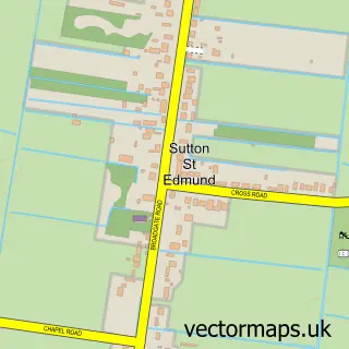
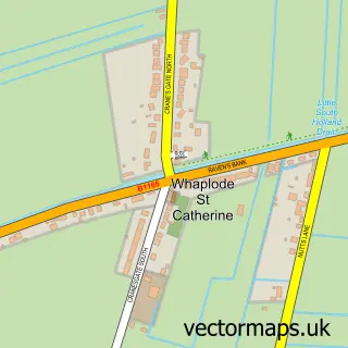
This Sutton St James street map is a detailed vector street map covering a 750m x 750m area. Select a larger area to create and download your own vector street map of Sutton St James.
The 750-metre map sample for Sutton St James covers 221 mapped buildings and approximately 10.1 km of road detail, of which 9 named roads are named. The immediate area includes 1 school, 1 pub and 1 MOT station. The wider area around Sutton St James features 1 food and drink venue. To create a larger or custom map of Sutton St James, the map builder lets you define your own coverage area and download editable SVG, PDF and PNG files.
Create a larger editable map of Sutton St James
Choose any area you need and generate a high-quality vector map instantly. Perfect for print, planning, design, business and personal use.

This Sutton St James street map in Lincolnshire is available as downloadable SVG, PDF and PNG map files, or as a printed map for planning, business, display, education, local information and design work. You can also create a larger custom map area using the map selector.
What this Sutton St James map sample shows
Sutton St James lies within Sutton St. James Cp parish, part of The Saints ward in the South Holland District local authority area. The postcode geography for this area includes the PE postcode area, the PE12 postcode district and the PE12 0 postcode sector. Residents fall under the Nhs Lincolnshire Integrated Care Board for NHS services.
Local features near Sutton St James
Within 2 milesAmenities and services in and around Sutton St James.
Administrative and postcode information for Sutton St James
The local authority covering Sutton St James is South Holland District, within the county of Lincolnshire. The settlement lies within The Saints ward and Sutton St. James Cp civil parish. The PE12 postcode district and PE12 0 postcode sector serve the immediate area. NHS provision in the area is delivered through The Queen Elizabeth Hospital, King's Lynn, Nhs Foundation Trust.
Nearby street map samples around Sutton St James

More street maps in Lincolnshire
750 metre map area coverage
Boundary, postcode and point of interest information for the 750m x 750m rectangle centred on this sample map.
Boundaries containing map centre
Constituency: South Holland and The Deepings Co Const
County: Lincolnshire County
District: South Holland District
Icb: NHS Lincolnshire ICB
Parish: Sutton St. James CP
Police Force: lincolnshire
Postcode District: PE12
Postcode Sector: PE12 0
Ward: The Saints Ward
Nearby boundaries intersecting sample
No additional intersecting boundaries found.
Postcode coverage
POI category counts
Beauty Salon: 2
Books Mags Music And Video: 2
Anglican Church: 1
Antique Store: 1
Baptist Church: 1
Building Supply Store: 1
Business Consulting: 1
Elementary School: 1
Gas Station: 1
Gun And Ammo: 1
Sample points of interest
- St James The Greater, Sutton St James
- The Gunner's Store
- Sutton St James Baptist Church
- Cutigel
- Pennys Hair And Beauty Lounge
- Post Office-Sutton St. James
- Sutton St. James Post Office
- Lenton Joinery
- Merivium Associates
- Sutton St James Community Primary School
- Pace
- The Gunner's Store, Sutton St James, South Lincolnshire
Create a larger editable map of Sutton St James
This sample shows only a 750 metre area. To create a larger map of Sutton St James, use our map builder to choose your own coverage area, add titles and download editable SVG, PDF and PNG files.
Create a custom map of Sutton St James