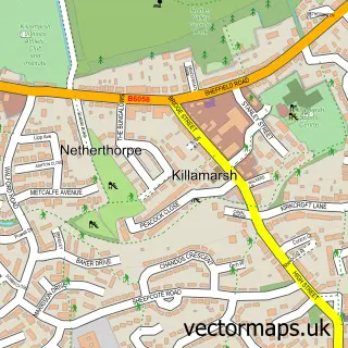
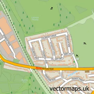
This Swallownest street map is a detailed vector street map covering a 750m x 750m area. Select a larger area to create and download your own vector street map of Swallownest.
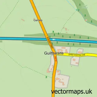
The 750-metre map sample for Swallownest covers 577 mapped buildings and approximately 25.5 km of road detail, of which 44 named roads are named. The immediate area includes 1 school, 1 GP surgery, with 3 within 2 miles and 10 MOT stations within 2 miles. The wider area around Swallownest features 3 food and drink venues. To create a larger or custom map of Swallownest, the map builder lets you define your own coverage area and download editable SVG, PDF and PNG files.
Create a larger editable map of Swallownest
Choose any area you need and generate a high-quality vector map instantly. Perfect for print, planning, design, business and personal use.

This Swallownest street map in South Yorkshire is available as downloadable SVG, PDF and PNG map files, or as a printed map for planning, business, display, education, local information and design work. You can also create a larger custom map area using the map selector.
What this Swallownest map sample shows
Swallownest lies within Aston Cum Aughton Cp parish, part of Holderness ward in the Rotherham District (B) local authority area. The postcode geography for this area includes the S postcode area, the S26 postcode district and the S26 4 postcode sector. Residents fall under the Nhs South Yorkshire Integrated Care Board for NHS services.
Local features near Swallownest
Within 2 milesAmenities and services in and around Swallownest.
Administrative and postcode information for Swallownest
The local authority covering Swallownest is Rotherham District (B), within the county of South Yorkshire. The settlement lies within Holderness ward and Aston Cum Aughton Cp civil parish. The S26 postcode district and S26 4 postcode sector serve the immediate area. NHS provision in the area is delivered through The Rotherham Nhs Foundation Trust.
Nearby street map samples around Swallownest

More street maps in South Yorkshire
750 metre map area coverage
Boundary, postcode and point of interest information for the 750m x 750m rectangle centred on this sample map.
Boundaries containing map centre
Constituency: Rother Valley Co Const
District: Rotherham District (B)
Icb: NHS South Yorkshire ICB
Parish: Aston cum Aughton CP
Police Force: south yorkshire
Postcode District: S26
Postcode Sector: S26 4
Ward: Aughton & Swallownest Ward
Nearby boundaries intersecting sample
Ward: Aston & Todwick Ward
Postcode coverage
POI category counts
Beauty Salon: 7
Hair Salon: 7
Barber: 3
Chinese Restaurant: 3
Dentist: 3
Tanning Salon: 3
Cafe: 2
Community Services Non Profits: 2
Cremation Services: 2
Driving School: 2
Sample points of interest
- Graeme Hinchliffe Associates
- Maranto's
- Christ Church
- Pottery Creations at Studio 7
- Swallownest Nursing Home
- The Cooperative Food (BF) Swallownest (ERF), Swallownest
- Greens Car Spares
- Swift Autocentre
- FA Smiths Bakery Swallonest
- RBS
- The Royal Bank of Scotland
- Swallownest Baptist Church
Create a larger editable map of Swallownest
This sample shows only a 750 metre area. To create a larger map of Swallownest, use our map builder to choose your own coverage area, add titles and download editable SVG, PDF and PNG files.
Create a custom map of Swallownest